
Acta Scientiarum Naturalium Universitatis Pekinensis ›› 2017, Vol. 53 ›› Issue (4): 701-709.DOI: 10.13209/j.0479-8023.2017.060
• Orginal Article • Previous Articles Next Articles
Received:2016-02-24
Revised:2016-06-07
Online:2017-07-20
Published:2017-07-20
基金资助:CLC Number:
Zhifang WANG, Ganglu ZHU. A Study on Characteristic Changes and Causes of Pond Landscape Systems in the Process of Urbanization[J]. Acta Scientiarum Naturalium Universitatis Pekinensis, 2017, 53(4): 701-709.
王志芳, 朱刚露. 城镇化过程中陂塘景观系统的特征演变与成因分析[J]. 北京大学学报自然科学版, 2017, 53(4): 701-709.
Add to citation manager EndNote|Ris|BibTeX
URL: https://xbna.pku.edu.cn/EN/10.13209/j.0479-8023.2017.060

Fig. 1 Location (a) and surrounding environment (b) of the study area within Chongqing
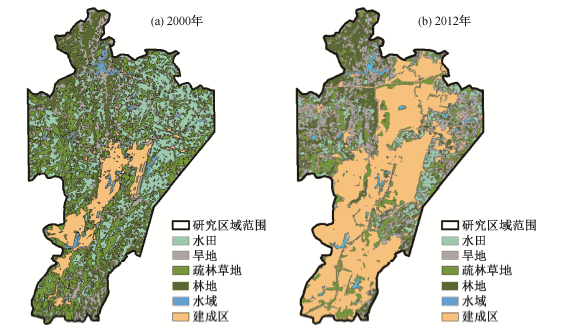
Fig. 2 Land use of the study area in 2000 and 2012
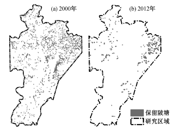
Fig. 3 Space distribution map of ponds reserved in 2000 and 2012
| 年份 | 数量 | 水面总面积/104m2 | 平均水面面积/104m2 | 最大面积/104m2 | 最小面积/m2 |
|---|---|---|---|---|---|
| 2000 | 1906 | 175.9 | 0.1 | 7.7 | 0.2 |
| 2012 | 270 | 59.2 | 0.2 | 3.3 | 2.2 |
Table 1 Changes of quantity characteristic of ponds
| 年份 | 数量 | 水面总面积/104m2 | 平均水面面积/104m2 | 最大面积/104m2 | 最小面积/m2 |
|---|---|---|---|---|---|
| 2000 | 1906 | 175.9 | 0.1 | 7.7 | 0.2 |
| 2012 | 270 | 59.2 | 0.2 | 3.3 | 2.2 |
| 年份 | 密度/10-6m-2 | 破碎度/10-4m-2 | 分离度 | 结构连接度 | |
|---|---|---|---|---|---|
| 平均距离/m | 平均最邻近距离/m | ||||
| 2000 | 16.4 | 10.8 | 10.3 | 5413.3 | 54.4 |
| 2012 | 2.3 | 4.6 | 53.5 | 5289.2 | 113.7 |
Table 2 Changes of spatial characteristic of ponds
| 年份 | 密度/10-6m-2 | 破碎度/10-4m-2 | 分离度 | 结构连接度 | |
|---|---|---|---|---|---|
| 平均距离/m | 平均最邻近距离/m | ||||
| 2000 | 16.4 | 10.8 | 10.3 | 5413.3 | 54.4 |
| 2012 | 2.3 | 4.6 | 53.5 | 5289.2 | 113.7 |
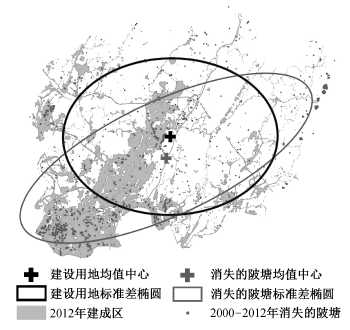
Fig. 4 Standard deviation ellipse of disappeared ponds and built-up area from 2000 to 2012
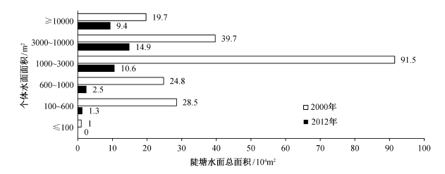
Fig. 5 Surface areas of ponds in different levels in 2000 and 2012
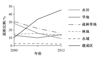
Fig. 6 PLAND of different matrices
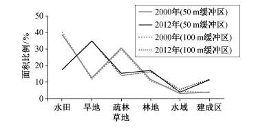
Fig. 7 PLAND of different matrices about 50 and 100 meters buffer zone around ponds
| 项目 | 用地类型 | 2012年用地面积/104m2 | 2000年用地 面积/104m2 | 2000年 面积比例% | 用地中陂塘 面积比例/% | ||||||
|---|---|---|---|---|---|---|---|---|---|---|---|
| 水田 | 旱地 | 疏林草地 | 林地 | 水域 | 建成区 | 陂塘 | |||||
| 2000年用地 面积/(104m2) | 水田 | 331.5 | 219.5 | 202.0 | 115.3 | 8.5 | 659.3 | 15.00 | 1551 | 36.8 | 37.9 |
| 旱地 | 10.3 | 160.3 | 66.8 | 56.8 | 3.0 | 218.3 | 1.0 | 516.5 | 12.2 | 9.3 | |
| 疏林草地 | 78.0 | 192.3 | 317.8 | 71.8 | 3.3 | 572.3 | 7.0 | 1242.25 | 29.4 | 27.6 | |
| 林地 | 33.5 | 65.8 | 29.3 | 195.5 | 5.8 | 138.5 | 4.0 | 472.3 | 11.2 | 9.6 | |
| 水域 | 6.0 | 8.5 | 7.3 | 5.3 | 28.00 | 49.5 | 4.3 | 108.8 | 2.6 | 11.5 | |
| 建成区 | 1.0 | 6.5 | 12.0 | 2.3 | 2.3 | 134.0 | 0.5 | 158.5 | 3.8 | 4.2 | |
| 陂塘 | 20.8 | 19.3 | 21.8 | 6.8 | 4.3 | 85.3 | 13.00 | 171 | 4.1 | 100 | |
| 2012年用地 面积/104m2 | 481 | 672 | 656.8 | 453.5 | 55 | 1857 | 44.75 | ||||
| 2012年面积 比例/% | 11.4 | 15.9 | 15. | 10.8 | 1.3 | 44.0 | 1.1 | ||||
| 用地中陂塘 面积比例/% | 15.7 | 32.5 | 12.2 | 15.7 | 11.9 | 12.0 | 100 | ||||
Table 3 Transition matrix of land
| 项目 | 用地类型 | 2012年用地面积/104m2 | 2000年用地 面积/104m2 | 2000年 面积比例% | 用地中陂塘 面积比例/% | ||||||
|---|---|---|---|---|---|---|---|---|---|---|---|
| 水田 | 旱地 | 疏林草地 | 林地 | 水域 | 建成区 | 陂塘 | |||||
| 2000年用地 面积/(104m2) | 水田 | 331.5 | 219.5 | 202.0 | 115.3 | 8.5 | 659.3 | 15.00 | 1551 | 36.8 | 37.9 |
| 旱地 | 10.3 | 160.3 | 66.8 | 56.8 | 3.0 | 218.3 | 1.0 | 516.5 | 12.2 | 9.3 | |
| 疏林草地 | 78.0 | 192.3 | 317.8 | 71.8 | 3.3 | 572.3 | 7.0 | 1242.25 | 29.4 | 27.6 | |
| 林地 | 33.5 | 65.8 | 29.3 | 195.5 | 5.8 | 138.5 | 4.0 | 472.3 | 11.2 | 9.6 | |
| 水域 | 6.0 | 8.5 | 7.3 | 5.3 | 28.00 | 49.5 | 4.3 | 108.8 | 2.6 | 11.5 | |
| 建成区 | 1.0 | 6.5 | 12.0 | 2.3 | 2.3 | 134.0 | 0.5 | 158.5 | 3.8 | 4.2 | |
| 陂塘 | 20.8 | 19.3 | 21.8 | 6.8 | 4.3 | 85.3 | 13.00 | 171 | 4.1 | 100 | |
| 2012年用地 面积/104m2 | 481 | 672 | 656.8 | 453.5 | 55 | 1857 | 44.75 | ||||
| 2012年面积 比例/% | 11.4 | 15.9 | 15. | 10.8 | 1.3 | 44.0 | 1.1 | ||||
| 用地中陂塘 面积比例/% | 15.7 | 32.5 | 12.2 | 15.7 | 11.9 | 12.0 | 100 | ||||
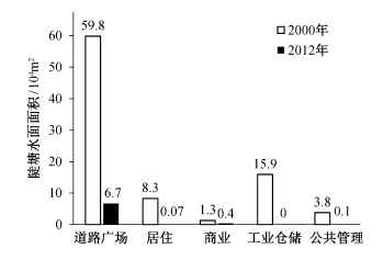
Fig. 8 Surface areas of ponds within five kinds of built-up districts
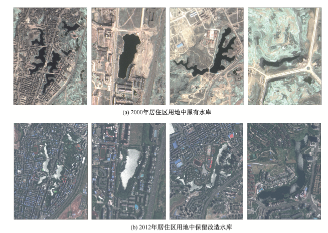
Fig. 9 Reservoirs of residential area in 2000 and 2012
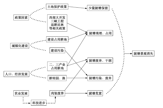
Fig. 10 Analysis of the causes of the pond decrease
| 缓冲区/m | 陂塘面积比/% | |
|---|---|---|
| 2000年 | 2012年 | |
| 0~200 | 5.4 | 40.0 |
| 200~400 | 5.4 | 29.8 |
| 400~600 | 5.6 | 14.5 |
| 600~800 | 8.8 | 7.6 |
| 800~1000 | 6.2 | 2.2 |
| >1000 | 68.6 | 5.9 |
Table 4 Area ratio of ponds in different buffers around road
| 缓冲区/m | 陂塘面积比/% | |
|---|---|---|
| 2000年 | 2012年 | |
| 0~200 | 5.4 | 40.0 |
| 200~400 | 5.4 | 29.8 |
| 400~600 | 5.6 | 14.5 |
| 600~800 | 8.8 | 7.6 |
| 800~1000 | 6.2 | 2.2 |
| >1000 | 68.6 | 5.9 |
| [1] | 杭宏秋.陂塘兴废的正负效应及思考. 古今农业, 2001(4): 12-17 |
| [2] | 张芳. 中国古代灌溉工程技术史.太原: 山西教育出版社, 2009: 107-128, 462-480 |
| [3] | 肖克非.关于皖中左陵区防旱问题的意见. 安徽农业科学, 1980(2): 3-8 |
| [4] | 涂安国, 尹炜, 陈德强, 等. 多水塘系统调控农业非点源污染研究综述. 人民长江, 2009, 40(21): 71-73 |
| [5] | 孙璞. 农村水塘对地块氮磷流失的截留作用研究. 水资源保护, 1998(1): 1-4, 12 |
| [6] | 陶文星, 喻光明, 李智国, 等. 农村土地整理中的堰塘整理及其对生态环境的影响: 以湖北省武穴市魏高邑镇土地整理项目为例. 农业发展与环境, 2007, 24(4): 5-10 |
| [7] | 张妤琳, 刘晓南, 赵宇, 等. 快速城市化地区塘的消减过程研究: 以广州市天河区为例. 生态环境学报, 2014, 23(2): 244-251 |
| [8] | 戴芹芹, 王志芳. 重庆堰塘-冲冲田系统对现代水资源管理的启示. 中国水利, 2015(1): 34-37 |
| [9] | Horton G A.Water words dictionary: a compilation of technical water, water quality, environmental, and water-related terms. Nevada: Nevada Division of Water Resources, 2000: 487 |
| [10] | Biggs J, Walker D, Whitfield M, et al.Pond action: promoting the conservation of ponds in Britain. Freshwater Forum, 1991, 1(2): 114-118 |
| [11] | Boothby J.Framing a strategy for pond landscape conservation: aims, objectives and issues. Landscape Research, 1999, 24(1): 67-83 |
| [12] | Huang S L, Lee Y C, Budd W, et al.Analysis of changes in farm pond network connectivity in the peri-urban landscape of the Taoyuan Area, Taiwan. Environmental Management, 2012, 49(4): 915-928 |
| [13] | Fang W T.A Landscape approach to reserving farm ponds for wintering bird refuges in Taoyuan, Taiwan [D]. Texas: Texas A&M University, 2005 |
| [14] | Froneman A, Mangnall M J, Little R M, et al.Waterbird assemblages and associated habitat charac-teristics of farm ponds in the Western Cape, South Africa. Biodiversity & Conservation, 2001, 10(2): 251-270 |
| [15] | Yin C, Shan B.Multipond systems: a sustainable way to control diffuse phosphorus pollution. AMBIO: A Journal of the Human Environment, 2001, 30(6): 369-375 |
| [16] | 俞孔坚, 姜芊孜, 王志芳, 等. 陂塘景观研究进展与评述. 地域研究与开发, 2015, 34(4): 1-2 |
| [17] | Francl K E, Schnell G D.Relationships of human disturbance, bird communities, and plant communities along the land-water interface of a large reservoir. Environmental Monitoring and Assessment, 2002, 73(1): 67-93 |
| [18] | Chou W W, Lee S H, Wu C F.Evaluation of the preservation value and location of farm ponds in Yunlin County, Taiwan. International Journal of Environmental Research and Public Health, 2013, 11(1): 548-572 |
| [19] | Tischendorf L, Fahrig L.On the usage and mea-surement of landscape connectivity. Oikos, 2000, 90(1): 7-19 |
| [20] | 邵怀勇, 仙巍, 杨午年. 三峡水库建设前后10年库区景观空间格局动态变化研究: 以重庆开县为例. 测绘科学, 2008, 33(6): 175-178 |
| [21] | Downing J A, Cole J J, Middelburg J J, et al.Sediment organic carbon burial in agriculturally eutrophic impoundments over the last century. Global Biogeochemical Cycles, 2008, 22(1): 10-18 |
| [22] | Wu J S, Holman R E, Dorney J R.Systematic evaluation of pollutant removal by urban wet deten-tion ponds. Journal of Environmental Engineering, 1996, 122(11): 983-988 |
| [23] | Scheffer M, Geest G J Van,Zimmer K,et al.Small habitat size and isolation can promote species rich-ness: second-order effects on biodiversity in Shallow Lakes and Ponds. Oikos, 2006, 112(1): 227-231 |
| [24] | 吴昌广, 周志翔. 景观连接度的概念、度量及其应用. 生态学报, 2010, 30(7): 1903-1910 |
| [25] | 由畅, 周永斌, 于丽芬. 景观破碎化数量分析方法概述. 中国农学通报, 2006, 22(5): 146-151 |
| [26] | 重庆市统计局.重庆统计年鉴.北京: 中国统计出版社, 1999-2014 |
| [27] | 陈娴椒, 倪凤娣, 周维禄, 等. 重庆市耕地变化及驱动力分析. 西南农业大学学报, 2010, 8(4): 15-19 |
| [28] | 周于翔, 骆东奇, 莫良玉. 重庆市耕地利用动态变化及其驱动力研究. 国土资源科技管理, 2007, 24(6): 7-11 |
| [1] | HUANG Zhiji, LIU Boya. Could Digital Inclusive Finance Promote the Development of New Urbanization? [J]. Acta Scientiarum Naturalium Universitatis Pekinensis, 2025, 61(3): 557-568. |
| [2] |
LIU Wei, LIU Mengzi, GONG Yue, QUE Jinnan, GUO Chuanmin.
Impacts of Western Urban Planning on Residential Segregation and Their Inspiration
[J]. Acta Scientiarum Naturalium Universitatis Pekinensis, 2024, 60(5): 945-956.
|
| [3] | WANG Nan, HAO Jinmin, HOSHINO Satoshi, TIAN Yufu. Study on the Relationship Between Industrial Structure and Land Use Structure of Rural Areas in Huang-Huai-Hai Plain: A Case Study of Quzhou County [J]. Acta Scientiarum Naturalium Universitatis Pekinensis, 2023, 59(5): 801-812. |
| [4] |
LI Xiaojing, HAO Jianhua, CAI Yinfei, SUN Yanan.
Impact of Urbanization and Industrial Collaborative Agglomeration on Land Use Efficiency of Resource-Based Cities in the Yellow River Basin, China
[J]. Acta Scientiarum Naturalium Universitatis Pekinensis, 2023, 59(4): 681-694.
|
| [5] | CAO Jiyang, GONG Yue, LI Jiheng, PENG Hui. Integration of Towns and Industrial Zones in Pearl River Delta: A Case Study of Shishan and Songshanhu [J]. Acta Scientiarum Naturalium Universitatis Pekinensis, 2023, 59(3): 489-500. |
| [6] | CHEN Yanguang. Boltzmann Model of Growth Curve of the β Index for Traffic Networks [J]. Acta Scientiarum Naturalium Universitatis Pekinensis, 2023, 59(2): 326-330. |
| [7] | WU Jianan, CHU Jun, SUN Yiyu, CHAO Heng. Analysis of Urban Land Use Function Identification in Shenzhen Based on SOFM Network [J]. Acta Scientiarum Naturalium Universitatis Pekinensis, 2022, 58(4): 664-672. |
| [8] | HU Yeting, LI Tianhong. Forecasting Spatial Pattern of Land Use Change in Rapidly Urbanized Regions Based on SD-CA Model [J]. Acta Scientiarum Naturalium Universitatis Pekinensis, 2022, 58(2): 372-382. |
| [9] |
JI Zhengxin, XU Yueqing, HUANG An, LU Longhui, DUAN Yaming.
Spatial Pattern and Evolution Characteristics of the Production-Living-Ecological Space in the Mountainous Area of Northern Hebei Province: A Case Study of Zhangjiakou City
[J]. Acta Scientiarum Naturalium Universitatis Pekinensis, 2022, 58(1): 123-134.
|
| [10] | WANG Hongliang, GAO Yining, WU Jiansheng, WANG Na, ZHAO Yuhao, PENG Zifeng, WANG Yanglin. Construction Land Expansion and Its Driving Force in Highly Urbanization Areas: A Case Study of Shenzhen City [J]. Acta Scientiarum Naturalium Universitatis Pekinensis, 2021, 57(4): 707-715. |
| [11] |
LI Mingjing, QI Yingjun, LI Wenjun.
Livestock Keeping of Migrant Households from Perspective
of Livelihood and Ecology: A Case Study in Yushu Tibetan
Autonomous Prefecture, Qinghai Province
[J]. Acta Scientiarum Naturalium Universitatis Pekinensis, 2021, 57(4): 773-782.
|
| [12] |
XU Nuanyin, LI Zhijian, ZENG Hui.
Spatio-Temporal Dynamic Characteristics of Coupling and Coordination of Urbanization System: Case Study in the Coastal Zone of East China Sea
[J]. Acta Scientiarum Naturalium Universitatis Pekinensis, 2021, 57(3): 536-544.
|
| [13] | LIN Ping. Urbanization Effects on Mammal Richness: A Case Study of Yangtze River Delta Urban Agglomeration [J]. Acta Scientiarum Naturalium Universitatis Pekinensis, 2021, 57(3): 565-574. |
| [14] |
MENG Jijun, ZHU Lijun, WANG Qi, GUO Liren, ZHANG Weijia.
Influence of Policy-Driven Land Use Transformation on Multifunctional Land Use in the Middle Reaches of the Heihe River Basin
[J]. Acta Scientiarum Naturalium Universitatis Pekinensis, 2020, 56(6): 1102-1112.
|
| [15] | ZHOU Xiaokang, LI Jing, ZHAO Xinyi. Spatial-temporal Change and Land Use Analysis of Beijing Urban Heat Island Based on Hourly Temperature Data [J]. Acta Scientiarum Naturalium Universitatis Pekinensis, 2020, 56(5): 939-949. |
| Viewed | ||||||
|
Full text |
|
|||||
|
Abstract |
|
|||||