Acta Scientiarum Naturalium Universitatis Pekinensis ›› 2017, Vol. 53 ›› Issue (6): 1011-1020.DOI: 10.13209/j.0479-8023.2017.051
• Orginal Article • Previous Articles Next Articles
Jian SONG1,2, Fangtou TANG1, Zhihui DENG3, Yugui GUO4
Received:
Revised:
Online:
Published:
宋键1,2, 唐方头1, 邓志辉3, 郭玉贵4
基金资助:
Abstract:
Based on the geological survey, trench excavation, drilling exploration and geological dating methods, detailed analysis and comprehensive research were carried on Cangkou fault in Huangdao. Results show that Cangkou fault distribution in Huangdao bay free trade zone, the Wujiazhuang, Changjiang road subdistrict office, Xinzhuang, Gaojiatai, Zhangjiazhuang, Xiaowa, Baiguo village, and into the Yellow Sea near Xinjian village. In Huangdao, Cangkou fault direction is north-east, and tendency is north-west. The length is about 15 km. The width of the fault zone is between 5 and 35 m. Cangkou fault is mainly developed in the Yanshan period granite. The cretaceous strata, modern geomorphology and quaternary deposits are controlled by Cangkou fault. Since the middle Pleistocene, the main movement is right lateral strike slip with thrust movement after multi period movement. The fault zone is interrupted by the fault mud. Bedrock near fault zone is broken. For security reasons, the authors suggest considering 14 m width as the safety distance of the Cangkou fault in Huangdao. The research of the spatial distribution and the present activity of Cangkou fault in Huangdao has important significance to the reasonable planning, comprehensive development and utilization of land, the seismic geological disaster assess-ment of engineering in the future.
Key words: Cangkou fault, geometric structure, activity feature
摘要:
通过地质和地貌调查、探槽开挖、钻孔探测及地质年代测定等方法, 对沧口断裂黄岛段进行详细的研究。结果表明: 沧口断裂在黄岛前湾一带经保税区、武家庄、长江路街道办事处、辛庄、高家台、张家庄、小洼、白果树村和新建村进入黄海; 沧口断裂带在黄岛整体上呈北东走向, 倾向北西, 长约15 km, 断裂带宽度在5~35 m之间; 断层主要发育在燕山花岗岩体中, 对白垩纪地层、现代地貌和第四纪沉积有一定的控制作用; 经过多期运动, 沧口断裂黄岛段中更新世以来以右旋走滑运动为主, 兼有逆冲运动, 断裂带中发育断层泥, 断裂带附近基岩破碎严重。出于安全考虑, 建议沧口断裂黄岛段采取14 m宽度作为避让带宽度。沧口断裂黄岛段空间展布及现代活动性的研究对未来青岛市黄岛区国土资源的合理规划、综合开发以及重大工程的地质灾害评价有重要意义。
关键词: 沧口断裂, 几何结构, 活动特征
Jian SONG, Fangtou TANG, Zhihui DENG, Yugui GUO. Geometric Structure and Activities Features of Cangkou Fault in Huangdao[J]. Acta Scientiarum Naturalium Universitatis Pekinensis, 2017, 53(6): 1011-1020.
宋键, 唐方头, 邓志辉, 郭玉贵. 沧口断裂黄岛段断裂几何结构和活动特征[J]. 北京大学学报自然科学版, 2017, 53(6): 1011-1020.
Add to citation manager EndNote|Ris|BibTeX
URL: https://xbna.pku.edu.cn/EN/10.13209/j.0479-8023.2017.051
https://xbna.pku.edu.cn/EN/Y2017/V53/I6/1011
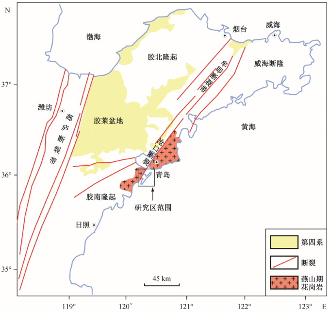
Fig. 1 Geological map of Qingdao and its adjacent area
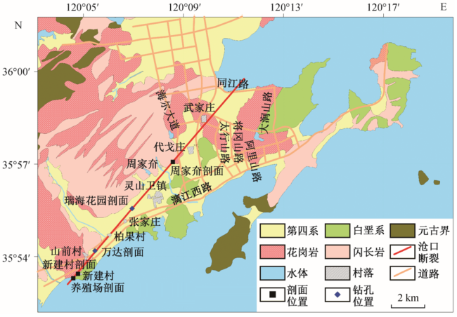
Fig. 2 Distribution of Huangdao section of Cangkou fault
Fig. 3 Fault profile of the logistics center (view to SW)
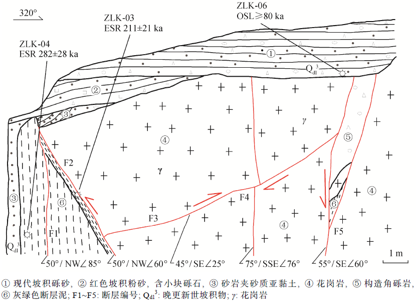
Table 1 Testing results of ages
Fig. 4 Trench exposure profile at the logistics center
Fig. 5 Cangkou fault profile in the southwest of Xinjian village
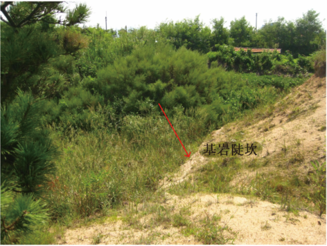
Fig. 6 Bedrock steep ridge near the profile in the south-west of Xinjian village (view to SW)
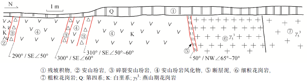
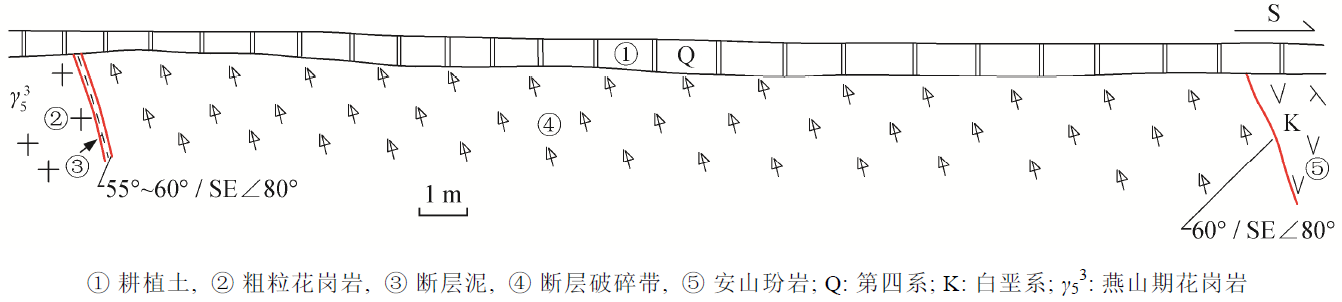
Fig. 7 Cangkou fault profile near the road to farm
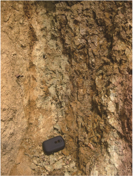
Fig. 8 Fault mud in the roadside profile to farm (view to NE)
Fig. 9 Boundary between fault broken section and andesitic porphyrite near the road to farm (view to NE)
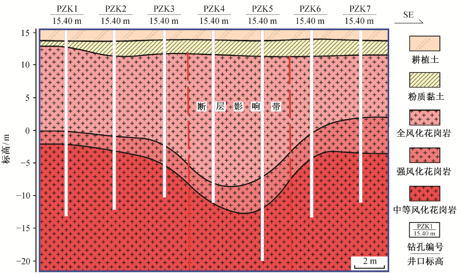
Fig. 10 Combined borehole profile in Ruihai garden
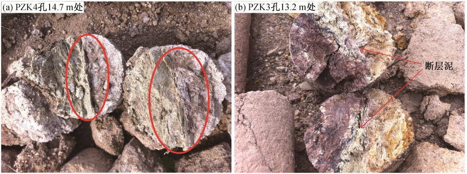
Fig. 11 Fault mud in strongly weathered block drill core in hole PZK5
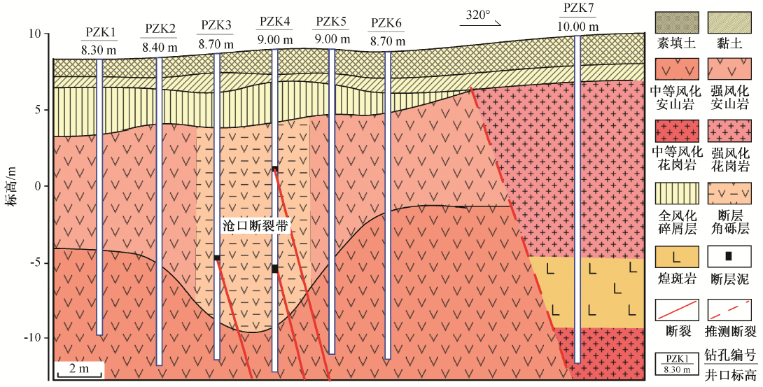
Fig. 12 The combined borehole profile in Wanda city
Fig. 13 Contact between fault mud and rock