
Acta Scientiarum Naturalium Universitatis Pekinensis ›› 2017, Vol. 53 ›› Issue (3): 451-461.DOI: 10.13209/j.0479-8023.2017.022
• Orginal Article • Previous Articles Next Articles
Jijun MENG, Xiaodong WANG, Zhen ZHOU( )
)
Received:2015-12-03
Revised:2016-04-15
Online:2017-05-20
Published:2017-05-20
基金资助:Jijun MENG, Xiaodong WANG, Zhen ZHOU. Integrated Landscape Pattern Optimization in Arid Region:A Case Study of Middle Reaches of Heihe River[J]. Acta Scientiarum Naturalium Universitatis Pekinensis, 2017, 53(3): 451-461.
蒙吉军, 王晓东, 周朕. 干旱区景观格局综合优化: 黑河中游案例[J]. 北京大学学报自然科学版, 2017, 53(3): 451-461.
Add to citation manager EndNote|Ris|BibTeX
URL: https://xbna.pku.edu.cn/EN/10.13209/j.0479-8023.2017.022

Fig. 1 Roadmap of study
| 景观类型 | 当量因子(E0) | 景观类型 | 当量因子(E0) |
|---|---|---|---|
| 林地 | 5.59 | 耕地 | 1.70 |
| 高覆被草地 | 4.52 | 湿地 | 160.24 |
| 中覆被草地 | 3.53 | 建设用地 | 0.10 |
| 低覆被草地 | 2.58 | 荒漠和戈壁 | 0.10 |
Table 1 Basic equivalent value per unit area of ecological service in the middle reaches of Heihe River
| 景观类型 | 当量因子(E0) | 景观类型 | 当量因子(E0) |
|---|---|---|---|
| 林地 | 5.59 | 耕地 | 1.70 |
| 高覆被草地 | 4.52 | 湿地 | 160.24 |
| 中覆被草地 | 3.53 | 建设用地 | 0.10 |
| 低覆被草地 | 2.58 | 荒漠和戈壁 | 0.10 |
| 威胁因子 THREAT | 最大影响距离 MAX_DIST/km | 权重 WEIGHT | 衰退线性相关性 DECAY |
|---|---|---|---|
| 耕地 | 8 | 0.7 | 0 |
| 城市 | 10 | 1 | 0 |
| 农村居民点 | 5 | 0.6 | 0 |
| 工矿用地 | 8 | 0.8 | 0 |
| 一级道路 | 3 | 1 | 1 |
| 二级道路 | 1 | 0.7 | 1 |
| 荒漠 | 10 | 0.5 | 0 |
Table 2 Attributes of threat data in the middle reaches of Heihe River
| 威胁因子 THREAT | 最大影响距离 MAX_DIST/km | 权重 WEIGHT | 衰退线性相关性 DECAY |
|---|---|---|---|
| 耕地 | 8 | 0.7 | 0 |
| 城市 | 10 | 1 | 0 |
| 农村居民点 | 5 | 0.6 | 0 |
| 工矿用地 | 8 | 0.8 | 0 |
| 一级道路 | 3 | 1 | 1 |
| 二级道路 | 1 | 0.7 | 1 |
| 荒漠 | 10 | 0.5 | 0 |
| 地类名称 | 自然属性 | 耕地 | 城市用地 | 农村居民点 | 工矿用地 | 一级道路 | 二级道路 | 荒漠 |
|---|---|---|---|---|---|---|---|---|
| 林地 | 1 | 0.8 | 0.2 | 0.8 | 0.9 | 0.5 | 0.3 | 0.2 |
| 高覆被草地 | 1 | 0.7 | 0.2 | 0.8 | 0.9 | 0.5 | 0.3 | 0.4 |
| 中覆被草地 | 0.7 | 0.7 | 0.2 | 0.7 | 0.8 | 0.5 | 0.3 | 0.4 |
| 低覆被草地 | 0.4 | 0.7 | 0.2 | 0.7 | 0.8 | 0.6 | 0.4 | 0.5 |
| 湿地 | 1 | 1 | 0.8 | 0.8 | 0.8 | 0.1 | 0.1 | 0.8 |
| 耕地 | 0.4 | 0 | 1 | 1 | 1 | 0.6 | 0.6 | 0.8 |
| 城市用地 | 0 | 0 | 0 | 0 | 0 | 0 | 0 | 1 |
| 农村居民点 | 0 | 0 | 0 | 0 | 0 | 0 | 0 | 1 |
| 工矿用地 | 0 | 0 | 0 | 0 | 0 | 0 | 0 | 1 |
| 一级道路 | 0 | 0 | 0 | 0 | 0 | 0 | 0 | 1 |
| 二级道路 | 0 | 0 | 0 | 0 | 0 | 0 | 0 | 1 |
| 荒漠 | 0.1 | 0.5 | 0 | 0 | 0 | 0 | 0 | 0 |
Table 3 Habitat types and sensitivity of habitat types to each threat in the middle reaches of Heihe River
| 地类名称 | 自然属性 | 耕地 | 城市用地 | 农村居民点 | 工矿用地 | 一级道路 | 二级道路 | 荒漠 |
|---|---|---|---|---|---|---|---|---|
| 林地 | 1 | 0.8 | 0.2 | 0.8 | 0.9 | 0.5 | 0.3 | 0.2 |
| 高覆被草地 | 1 | 0.7 | 0.2 | 0.8 | 0.9 | 0.5 | 0.3 | 0.4 |
| 中覆被草地 | 0.7 | 0.7 | 0.2 | 0.7 | 0.8 | 0.5 | 0.3 | 0.4 |
| 低覆被草地 | 0.4 | 0.7 | 0.2 | 0.7 | 0.8 | 0.6 | 0.4 | 0.5 |
| 湿地 | 1 | 1 | 0.8 | 0.8 | 0.8 | 0.1 | 0.1 | 0.8 |
| 耕地 | 0.4 | 0 | 1 | 1 | 1 | 0.6 | 0.6 | 0.8 |
| 城市用地 | 0 | 0 | 0 | 0 | 0 | 0 | 0 | 1 |
| 农村居民点 | 0 | 0 | 0 | 0 | 0 | 0 | 0 | 1 |
| 工矿用地 | 0 | 0 | 0 | 0 | 0 | 0 | 0 | 1 |
| 一级道路 | 0 | 0 | 0 | 0 | 0 | 0 | 0 | 1 |
| 二级道路 | 0 | 0 | 0 | 0 | 0 | 0 | 0 | 1 |
| 荒漠 | 0.1 | 0.5 | 0 | 0 | 0 | 0 | 0 | 0 |
| 阻力因子 | 权重 系数 | 指标 | 阻力 系数 | |
|---|---|---|---|---|
| 景观类型* | 显性阻力 | 0.28 | 湿地 | 1 |
| 林地 | 10 | |||
| 高覆被草地 | 15 | |||
| 中覆被草地 | 20 | |||
| 低覆被草地 | 25 | |||
| 耕地 | 30 | |||
| 建设用地 | 100 | |||
| 荒漠和戈壁 | 80 | |||
| 隐性阻力 | 0.12 | Kriging插值 | - | |
| 地貌因子[ | 坡度(°) | 0.15 | <8 | 1 |
| 8~15 | 10 | |||
| 15~25 | 50 | |||
| 25~35 | 75 | |||
| >35 | 100 | |||
| 起伏度(°) | 0.15 | <25 | 1 | |
| 25~50 | 10 | |||
| 50~70 | 50 | |||
| 70~100 | 75 | |||
| >100 | 100 | |||
| 道路因子[ | 距离一级道路距离(铁路、国道、省道)(m) | 0.15 | 0~200 | 100 |
| 200~400 | 80 | |||
| 400~800 | 60 | |||
| 800~1600 | 40 | |||
| 1600~3200 | 20 | |||
| >3200 | 1 | |||
| 距离二级道路距离(县道、乡道、专用道)(m) | 0.15 | 0~150 | 100 | |
| 150~250 | 80 | |||
| 250~450 | 60 | |||
| 450~800 | 40 | |||
| 800~1000 | 20 | |||
| >1000 | 1 | |||
Table 4 Resistance factor weight and coefficient
| 阻力因子 | 权重 系数 | 指标 | 阻力 系数 | |
|---|---|---|---|---|
| 景观类型* | 显性阻力 | 0.28 | 湿地 | 1 |
| 林地 | 10 | |||
| 高覆被草地 | 15 | |||
| 中覆被草地 | 20 | |||
| 低覆被草地 | 25 | |||
| 耕地 | 30 | |||
| 建设用地 | 100 | |||
| 荒漠和戈壁 | 80 | |||
| 隐性阻力 | 0.12 | Kriging插值 | - | |
| 地貌因子[ | 坡度(°) | 0.15 | <8 | 1 |
| 8~15 | 10 | |||
| 15~25 | 50 | |||
| 25~35 | 75 | |||
| >35 | 100 | |||
| 起伏度(°) | 0.15 | <25 | 1 | |
| 25~50 | 10 | |||
| 50~70 | 50 | |||
| 70~100 | 75 | |||
| >100 | 100 | |||
| 道路因子[ | 距离一级道路距离(铁路、国道、省道)(m) | 0.15 | 0~200 | 100 |
| 200~400 | 80 | |||
| 400~800 | 60 | |||
| 800~1600 | 40 | |||
| 1600~3200 | 20 | |||
| >3200 | 1 | |||
| 距离二级道路距离(县道、乡道、专用道)(m) | 0.15 | 0~150 | 100 | |
| 150~250 | 80 | |||
| 250~450 | 60 | |||
| 450~800 | 40 | |||
| 800~1000 | 20 | |||
| >1000 | 1 | |||
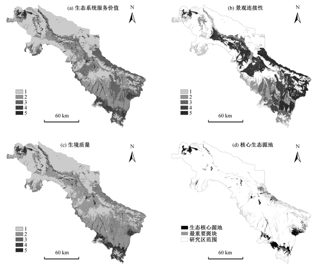
Fig. 2 Integrated identification of ecological source in the middle reaches of Heihe River

Fig. 3 Comprehensive ecological resistance surface (a) and the cumulative resistance surface (b)

Fig. 4 Ecological corridor (a) and nodes (b) in the middle reaches of Heihe River

Fig. 5 Frequency distribution of the minimum cumulative resistance values in the middle reaches of Heihe River

Fig. 6 Landscape function regionalization in the middle reaches of the Heihe River
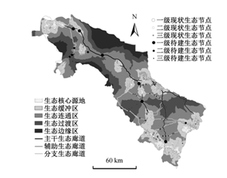
Fig. 7 Landscape ecological security pattern in the middle reaches of Heihe River
| [1] | 郭鹏程, 包安明. 基于生态压力指数的新疆生态安全时空动态分析. 中国沙漠, 2012, 32(1): 235-243 |
| [2] | 张宁, 常学礼, 李秀梅, 等. 基于沙漠化程度的生态安全格局评价. 中国沙漠, 2010, 30(2): 247-253 |
| [3] | 喻锋, 李晓兵, 王宏, 等. 皇甫川流域土地利用变化与生态安全评价. 地理学报, 2006, 61(6): 645-653 |
| [4] | 俞孔坚, 李海龙, 李迪华, 等. 国土尺度生态安全格局. 生态学报, 2009, 29(10): 5163-5175 |
| [5] | 肖笃宁, 陈文波, 郭福良, 等. 论生态安全的基本概念和研究内容. 应用生态学报, 2002, 13(3): 354-358 |
| [6] | 陈利顶, 傅伯杰, 赵文武. “源”“汇”景观理论及其生态学意义. 生态学报, 2006, 26(5): 1444-1449 |
| [7] | 叶玉瑶, 苏泳娴, 张虹欧, 等. 生态阻力面模型构建及其在城市扩展模拟中的应用. 地理学报, 2014, 69(4): 485-496 |
| [8] | 俞孔坚. 生物保护的景观生态安全格局. 生态学报, 1999, 19(1): 8-15 |
| [9] | 蒙吉军, 朱利凯, 杨倩, 等. 鄂尔多斯市土地利用生态安全格局构建. 生态学报, 2012, 32(21): 6755-6766 |
| [10] | 蒙吉军, 燕群, 向芸芸. 鄂尔多斯土地利用生态安全格局优化及方案评价. 中国沙漠, 2014, 34(2): 590-596 |
| [11] | 潘竟虎, 刘晓. 基于空间主成分和最小累积阻力模型的内陆河景观生态安全评价与格局优化: 以张掖市甘州区为例. 应用生态学报, 2015, 26(10): 3126-3136 |
| [12] | 朱磊, 刘雅轩. 基于GIS 和元胞自动机的玛纳斯河流域典型绿洲景观格局优化. 干旱区地理, 2013, 36(5): 946-954 |
| [13] | Yue Depeng, Wang Jiping, Liu Yongbing, et al.Ecologically based landscape pattern optimization in northwest of Beijing. Journal of Geographical Scien-ces, 2009, 19(3): 359-372 |
| [14] | 马克明, 傅伯杰, 黎晓亚, 等. 区域生态安全格局: 概念与理论基础. 生态学报, 2004, 24(4): 761-768 |
| [15] | 刘洋, 蒙吉军, 朱利凯. 区域生态安全格局研究进展. 生态学报, 2010, 30(24): 6980-6989 |
| [16] | 李潇然, 李阳兵, 王永艳, 等. 三峡库区县域景观生态安全格局识别与功能分区: 以奉节县为例. 生态学杂志, 2015, 34(7): 1959-1967 |
| [17] | 吴健生, 张理卿, 彭建, 等. 深圳市景观生态安全格局源地综合识别. 生态学报, 2013, 33(13): 4125-4133 |
| [18] | 李晶, 蒙吉军, 毛熙彦. 基于最小累积阻力模型的农牧交错带土地利用生态安全格局构建: 以鄂尔多斯市准格尔旗为例. 北京大学学报(自然科学版), 2013, 49(4): 707-715 |
| [19] | 朱磊, 刘雅轩. 基于GIS 和元胞自动机的玛纳斯河流域典型绿洲景观格局优化. 干旱区地理, 2013, 36(5): 946-954 |
| [20] | Mao Xiyan, Meng Jijun, Xiang Yunyun.CA-based model for developing land use ecological security pattern in semi-arid areas: a case study of Ordos, Inner Mongolia, China. Environmental Earth Scien-ces, 2013, 70(1): 269-279 |
| [21] | 王棒, 关文彬, 吴建安, 等. 生物多样性保护的区域生态安全格局评价手段: GAP 分析. 水土保持研究, 2006, 13(1): 192-196 |
| [22] | Fischer G, Nachtergaele F, Prieler S, et al.Global agro-ecological zones assessment for agriculture (GAEZ 2008). Laxenburg: IIASA, 2008 |
| [23] | Greenberg J A, Rueda C, Hestir E L, et al.Least cost distance analysis for spatial interpolation. Computers & Geosciences, 2011, 37: 272-276 |
| [24] | 周锐, 王新军, 苏海龙, 等. 平顶山新区生态用地的识别与安全格局构建. 生态学报, 2015, 35(6): 2003-2012 |
| [25] | 程国栋, 肖笃宁, 王根绪. 论干旱区景观生态特征与景观生态建设. 地球科学进展, 1999, 14(1): 11-15 |
| [26] | 蒙吉军, 吴秀芹, 李正国. 黑河流域LUCC(1988-2000)的生态环境效应研究. 水土保持研究, 2005, 12(4): 17-21 |
| [27] | 李静, 桑广书. 西汉以来黑河流域绿洲演变. 干旱区地理, 2010, 33(3): 480-486 |
| [28] | 赵锐锋, 姜朋辉, 赵海莉, 等. 黑河中游湿地景观破碎化过程及其驱动力分析. 生态学报, 2013, 33(14): 4436-4449 |
| [29] | 谢高地, 鲁春霞, 冷允法, 等. 青藏高原生态资产的价值评估. 自然资源学报, 2003, 18(2): 189-196 |
| [30] | 刘海龙, 石培基, 李生梅, 等. 河西走廊生态经济系统协调度评价及其空间演化. 应用生态学报, 2014, 25(12): 3645-3654 |
| [31] | Taylor P, Fahrig L, Henein K, et al.Connectivity is a vital element of landscape structure. Oikos, 1993, 68(3): 571-573 |
| [32] | Petrosillo I, Zaccarelli N, Semeraro T, Zurlini G.The effectiveness of different conservation policies on the security of natural capital. Landscape and Urban Planning, 2009, 89(1/2): 49-56 |
| [33] | Forman R L, Goldman C R, Heanue K, et al.Road ecology: science and solutions. New York: Island Press, 2003 |
| [34] | Sharp R, Chaplin K R, Wood S, et al. InVEST3.1.0 user’s guide: integrated valuation of environmental services and tradeoffs [EB/OL]. (2014)[2014-11-20] |
| [35] | 刘志伟. 基于InVEST的湿地景观格局变化生态响应分析: 以杭州湾南岸地区为例[D]. 杭州: 浙江大学, 2014 |
| [36] | 王让虎, 李晓燕, 张树文, 等. 东北农牧交错带景观生态安全格局构建及预警研究: 以吉林省通榆县为例. 地理与地理信息科学, 2014, 30(2): 111-115 |
| [37] | 李滨生. 沙漠化地区造林种草的生态效益及其防治沙漠化的作用. 干旱区资源与环境, 1988, 2(4): 56-63 |
| [38] | 李晖, 易娜, 姚文璟, 等. 基于景观安全格局的香格里拉县生态用地规划. 生态学报, 2011, 31(20): 5928-5936 |
| [39] | 李道进, 逄勇, 钱者东, 等. 基于景观生态学源: 汇理论的自然保护区功能分区研究. 长江流域资源与环境, 2014, 23(21): 53-59 |
| [40] | 张玉虎, 于长青, 塔西甫拉提 · 特依拜, 等. 风景区生态安全格局构建方法研究: 以北京妙峰山风景区为例. 干旱区研究, 2008, 25(3): 420-425 |
| [1] |
LU Qingling, LIU Yuexin, GAO Yang, ZHANG Zhonghao, CUI Lihan, SUN Ximan.
Realization Path of Comprehensive Tourism in Leisure Agriculture Based on Perspective of Element Flow: A Case Study of Chongqing
[J]. Acta Scientiarum Naturalium Universitatis Pekinensis, 2023, 59(3): 523-531.
|
| [2] |
MENG Jijun, ZHU Lijun, WANG Qi, GUO Liren, ZHANG Weijia.
Influence of Policy-Driven Land Use Transformation on Multifunctional Land Use in the Middle Reaches of the Heihe River Basin
[J]. Acta Scientiarum Naturalium Universitatis Pekinensis, 2020, 56(6): 1102-1112.
|
| [3] | MENG Jijun, ZHOU Zhen, KUO Lijen. Grain for the Green Spatial Pattern Optimization in the Middle Reaches of Heihe River Based on Water Carrying Capacity [J]. Acta Scientiarum Naturalium Universitatis Pekinensis, 2019, 55(3): 526-536. |
| [4] | YOU Nanshan, MENG Jijun, SUN Mutian. Spatio-temporal Change of NDVI and Its Relationship with Climate in the Upper and Middle Reaches of Heihe River Basin from 2000 to 2015 [J]. Acta Scientiarum Naturalium Universitatis Pekinensis, 2019, 55(1): 171-181. |
| [5] | MENG Jijun, WANG Jiangwei, WANG Ya, ZHOU Zhen, JIANG Song. A Study of Ecological Water Requirement and Efficiency of Water Allocation Based on Oasis Irrigation Area Scale: A Case of Middle Reaches of Heihe River [J]. Acta Scientiarum Naturalium Universitatis Pekinensis, 2018, 54(1): 171-180. |
| [6] | WANG Ya, MENG Jijun. Spatial-Temporal Features of Hydrological Effects Caused by Land Use Changes in Middle Reaches of Heihe River Based on InVEST Model [J]. Acta Scientiarum Naturalium Universitatis Pekinensis, 2015, 51(6): 1157-1165. |
| [7] | ZHOU Xiang,ZHANG Xiaogang,HE Longbin,ZENG Hui. Equity Assessment on Urban Green Space Pattern Based on Human Behavior Scale and Its Optimization Strategy: A Case Study in Shenzhen [J]. Acta Scientiarum Naturalium Universitatis Pekinensis, 2013, 49(5): 892-898. |
| Viewed | ||||||
|
Full text |
|
|||||
|
Abstract |
|
|||||