
郑亦佳 , 何萍, 缪育聪
Yijia ZHENG
中图分类号:
P404
通讯作者:
Corresponding authors:
收稿日期:
2016-03-19
修回日期:
2016-06-4
网络出版日期:
2017-01-22
版权声明:
2017 《北京大学学报(自然科学版)》编辑部 《北京大学学报(自然科学版)》编辑部 所有
基金资助:
展开
摘要 为了探究昆明地区城市化对降水的影响, 利用中尺度气象模式 WRF (the weather research and forecas-ting model)耦合单层城市冠层模块, 对2012年5月24日夜间发生在昆明城区西部的一次强降水过程进行数值模拟研究。通过与卫星观测得到的降水空间分布进行对比, 发现WRF模式能较好地再现此次降水过程。城市的存在会较显著地改变城市地区的潜热和低层垂直运动, 使得位于城区的降水中心降水强度略有减小, 而城区下风向的降水有所增加, 降水增加的区域与 750 hPa 高度上的水汽通量辐合加强的区域相对应。城区降水中心降水量减少可能是由于城市下垫面抑制了低层大气的水汽供给。城区下风向降水增加的可能原因是该区域相对较强的垂直运动使得更多的水汽被输送到高层大气中, 有利于降水的增强。在目前的城市化水平上, 若昆明地区的城市进一步扩张, 城区下风向地区的垂直对流运动和大气不稳定度均会增强, 但城市下垫面对低层水汽供给的抑制作用也会增强, 这两种作用的同时存在会使得城市下风向地区降水的变化存在不确定性。
关键词:
Abstract A rainstorm process over west of Kunming city during the night of May 24, 2012 is numerically simulated to study the effect of urbanization on the precipitation by using the weather research forecasting model (WRF) numerical model with single-layer urban canopy model. It is found that the precipitation process is well simulated by comparing the spatial distribution of precipitation between the satellite observation and simulated result. The presence of the city changes the latent heat and low level vertical motion over urban area significantly, resulting in slight reduction of the precipitation intensity in the precipitation center and enhancement of the downwind precipitation. The area where precipitation increases coincides with the area where water vapor flux convergence at 750 hPa increases. The reduction of precipitation in center may be due to restraint of the moisture supply in the lower atmosphere by urban underlying. While the increase of precipitation over downwind area may result from the relatively strong vertical motion which transports more water into upper atmosphere. If the urbanization continues expansion from its current level, not only the vertical motion and atmospheric instability but also the limiting of the moisture supply in the lower atmosphere will be enhanced. The combination of these two effects will enlarge the uncertainty of precipitation over downwind area.
Keywords:
近几十年来, 随着我国的城市化进程, 特别是城市群的形成, 城市区域的地表物质能量平衡和动力、热力学特征都发生了改变。这些改变会对区域大气边界层、大气环流及区域气候和环境效应产生影响。目前, 关于城市化气候效应的研究主要针对城市热岛效应, 随着相关研究的逐步深入, 人们对城市热岛效应的认识日趋清晰[1,2,3,4,5]。这些研究主要关注我国平原地区的城市化效应, 有关云南高原地区的相关研究还很少。云南滇中城市群位于东亚季风最活跃的气候区, 同时也是全球气候脆弱地区之一, 该地区的城市化可能会对东亚季风产生一定的影响。研究云南高原地区城市化对区域降水的影响, 对认识区域降水机理和区域可持续发展具有重要意义。
早在 1921 年, Horton[6]就指出城市比乡村环境更容易触发雷暴, 这是关于城市对雷暴影响较早的研究。Lansberg[7]和Atkinson[8]的研究也证实, 大城市对降水类型有显著影响。20 世纪 70 年代有学者发现暖季降水在城市下风区增加的现象[9,10,11]。随后, 在世界各地开展的一系列与城市化降水效应相关的观测试验均表明, 城市对降水的强度、落区及触发会产生一定影响[12,13,14]。
大部分学者认为城市对降水的影响因素主要体现在三方面: 城市热岛效应、地表粗糙度和气溶胶浓度[15]。城市热岛作为大气低层的热源会影响局地大气的流动。已有研究表明, 城市的存在会影响边界层空气的垂直运动, 增强城市下风向空气的上升运动和城市区域的下沉运动, 导致下风向降水的增加[16,17,18]。Baik 等[19]用一个二维中尺度模式研究发现, 边界层越不稳定, 城市下风向由城市热岛引起的上升气流越强, 影响垂直范围越大。Lin 等[20]对台湾地区的研究表明, 城市热岛不仅会增加城市下风向的降水, 还可能影响城市所在平原地区降水及雷暴发生的位置。关于城市热岛对降水的影响, 还有一些学者得出不同的结论。Bornstein 等[21]研究了亚特兰大城市热岛效应辐合区与对流风暴触发之间的相互作用, 发现在静风条件下, 城市热岛效应会激发对流的产生, 从而使降水主要发生在城市区域。刘树华等[5]利用北京大学单层城市冠层模式UCMPKU (modified single layer urban canopy model of Peking University)与中尺度气象模式WRF耦合, 研究 2012 年 7 月 21 日北京大暴雨的发生发展机理, 发现城区地表相对较强的感热通量会加热低层大气, 使得低层大气边界层的位温层结不稳定度增加, 进而有利于对流的触发, 有可能会增加降雨量。此外, 城市热岛效应还可能与山谷风、海陆风环流相互作用, 共同影响城市雷暴和降水的发展和落区[22,23]。
城市地表的粗糙度比周围自然下垫面的粗糙度大, 因而流经城市区域的风速会有所减小。当气流流经高粗糙度的城市区域时, 区域尺度的气流可能会发生“绕流”, 并在城市的下风向产生辐合上升运动[24]。城市区域的大粗糙度动力学作用可能会导致一些对流降水系统在经过城区时出现“断裂”或“分叉”。Miao 等[25]利用中尺度模式研究了北京的夏季降水个例, 发现城市的存在会使得飑线在城区断裂成雷暴单体, 但这些雷暴单体对降水量的影响尚不清楚。
尽管对气溶胶在成云降水中是起抑制作用还是促进作用尚有争议, 但可以肯定的是, 气溶胶粒子作为云凝结核会影响云的微物理过程, 从而影响云的形成和降水的发展。Rosenfeld[26]利用卫星数据研究发现, 在工业区和城市空气污染排放源的下风向, 大气污染物的排放使得冰核和云凝结核增多, 层状云产生更多的小云滴, 云滴谱分布更加均匀, 降低了云水向雨水转化的效率, 从而抑制了城市下风向降水的产生。但是, 也有一些观测研究发现, 气溶胶浓度较高时, 降水有所增强[27,28]。在成云和降水过程中, 空气污染物的作用很复杂, 对对流的抑制作用或增强作用可能取决于云的类型、环境条件以及气溶胶颗粒的大小和浓度[29,30]。
以昆明市为中心的云南滇中城市群位于我国季风系统的上游, 地处孟加拉湾水汽及南海水汽输送的必经之路。该地区高影响气象灾害频繁, 是全球气候脆弱地区之一。根据云南省政府对滇中城市群的发展规划, 到2030年末, 滇中地区城镇化水平将达到 75%。随着滇中城市群的发展, 城市化对该区域的区域降水及气候的影响值得关注。本文利用中尺度气象模式 WRF (the weather research and fore-casting model), 对 2012 年 5 月 24 日夜间发生在昆明城区西部的一次强降水进行数值模拟, 探究城市化对此次降水过程的影响, 研究结果可以为进一步探究滇中城市群的发展对区域降水和我国季风区大气环流及季风降水的影响机理提供基础资料。
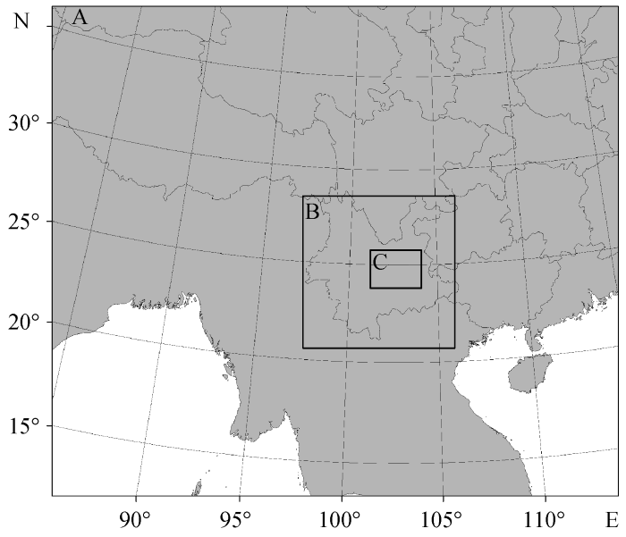
2012 年 5 月 24 日夜间, 昆明市区出现局地强雷雨天气, 降水从20:00 (北京时, 下同)开始, 降水中心位于昆明市区的西部, 降水区域自南向北移动, 昆明站的最大降水量为 85 mm, 已达到暴雨级别, 是昆明进入雨季以来的第一场暴雨。从天气形势上看, 随着高空500 hPa南支槽过境, 700 hPa的切变线和地面冷锋带来的南下冷空气与来自孟加拉湾和南海的暖湿气流在研究区域 C (图 1)内交汇, 是云南省典型的冷锋切变型降水。此次降水落区范围小, 局地性强, 与大范围大尺度天气系统导致的降水相比, 城市对此次降水的影响较明显。此次降水过程中, 研究区域C的大尺度近地面主导风为东风。
本研究使用的模式版本为 WRF v3.6.1, 由分辨率为 1°×1° 的 NCEP/NCAR 全球分析资料提供初始场和边界条件, 再分析资料每 6 小时输入一次。WRF 模式的模拟时间、模拟区域设置及参数化方案选择如表 1 所示。使用的地表类型资料为 2010 年的MODIS (the moderate resolution imaging spec-tra radiometer)地表类型数据, 分辨率为 500 m[31]。WRF 模式的模拟区域如图 1 所示, 采用三层双向嵌套, 模拟区域A, B, C的水平分辨率分别为 27, 4.5和1.5 km, 水平格点数分别为120×120, 131×131, 100×100。在垂直方向共设置 35 层, 采用上疏下密的分层方式。模拟区域的最内层(区域 C)以昆明市区为中心, 包括昆明以及滇池周边的大部分地区, 其土地利用类型如图 2(a)所示。模式的物理过程参数化方案选择如下: 微物理过程采用 Thompson graupel 方案[32]; 长短波辐射采用 RRTMG 方案[33]; 陆面过程采用 Noah 方案[34], 并启用单层城市冠层方案 UCM (Urban Canopy Model)来更好地模拟城市区域的气象场[35,36]; 对区域B和C采用 KF 积云对流方案[37]; 边界层方案采用 YSU 方案[38,39], 同时启用 YSU 方案的地形订正方案[40,41]。模拟时间为 2012 年 5 月 24 日 14:00 至 5 月 25 日 20:00, 包含整个降水时间段, 其中模拟的前 6 小时为模式调整时间。
表1 WRF模式模拟时间、模拟区域设置及参数化方案选择
Table 1 Run-time, domain configurations and physics options used in the WRF simulation
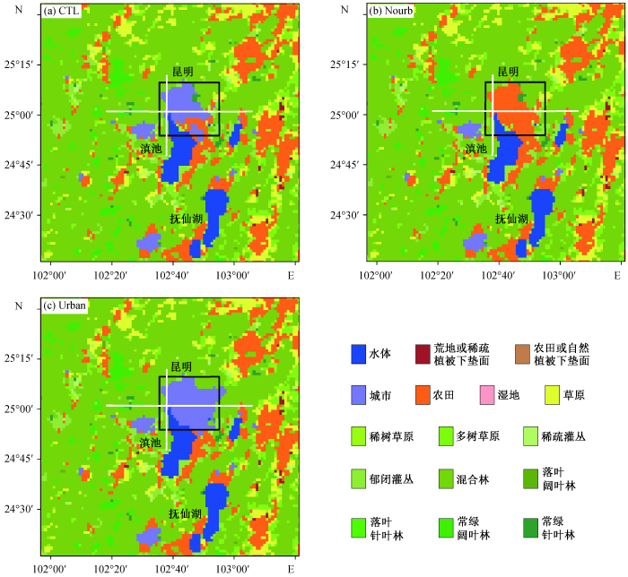
为探究城市在这次降水过程中的作用, 本研究设置 3 个敏感性试验(表 2): CTL 试验是控制试验, 直接采用MODIS的地表利用类型数据; Nourb试验为“无城市”的敏感性试验, 将 CTL 试验中的城市下
垫面替换为农田; Urban 试验为“城市扩张”的敏感性试验, 将 CTL 试验中城市周围的农田全都改变为城市下垫面。除地表利用类型外, 3 个敏感性试验的其他设置相同。各试验的区域 C 中下垫面土地利用类型分布如图2所示。
表2 敏感性试验中土地利用类型设置
Table 2 Landuse in different WRF model simulation
图2 各组试验模拟区域最内层的土地利用类型 Fig. 2 Landuse of the innermost domain in different WRF model simulation
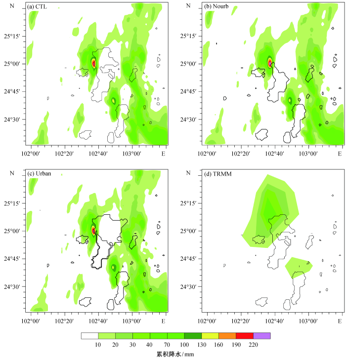
为了检验 WRF 模式对此次降水过程的模拟能力, 我们对比 WRF 模拟得到的累积降水与 TRMM (tropical rainfall measuring mission)热带降雨测量卫星的观测值。WRF 模拟得到的降水时间开始于
21:00, 比实际降水发生晚 1 小时, 降水发生的整个时间段为 2012 年 5 月 24 日 21:00 至 5 月 25 日05:00, 最大降水发生在 25 日 00:00。通过 TRMM资料(图 3(d))发现, 此次降水的中心位于昆明市的西部, WRF模式可以较好地模拟出这个降水中心, 但模拟的降水强度稍大。这种强度的差异可能与TRMM 卫星观测的灵敏度和反演算法有关[42,43]。此外, WRF模式还在昆明市的东面模拟出一条虚假的南北走向降水带, 但该降水带位于昆明市的上风向(大尺度近地面主导风为东风), 因此不是本文分析的对象。下面重点分析昆明市区西部降水过程, 探究城市化对城市区域及城市下风向降水的影响。
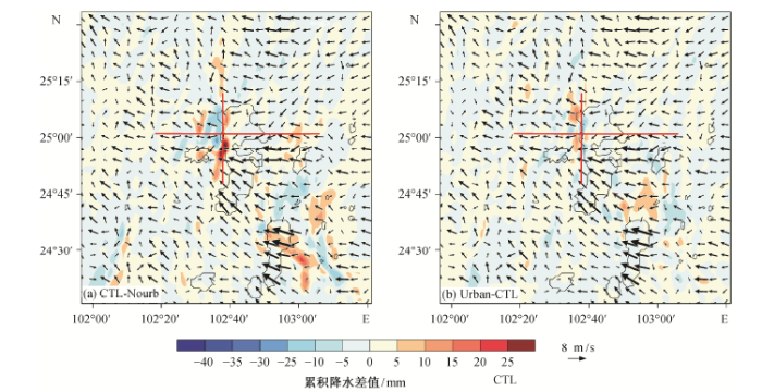
图 3给出 2012 年 5 月 24 日 21:00 至 25 日05:00 WRF模拟得到的累积降水, 可以看到, 3 个数值试验降水范围比较一致。其中, Nourb 试验模拟的降水中心强度最大, 累积降水超过 220 mm。CTL 试验与 Urban 试验模拟得到的降水中心累积降水量相当。图 4 给出不同试验累积降水的差值场, 图中叠加的风场为降水时段内 CTL 试验模拟得到的 10 m 的平均风场。从图 4 可以更明显地看出, 降水增加的区域位于昆明城区的西南面, 累积降水增加量最大可以达到 30 mm, 而降水减少的区域位于降水中心, 累积降水的减少量约为 25~30 mm。值得注意的是, 降水时段内昆明城区的近地面主导风向为东北风, 而滇池湖区上空的主导风向为东南风, 降水增加的区域正是这两支气流的交汇处, 同时也是城区的下风向。对比 CTL 试验和 Urban 试验的累积降水发现, 当城市进一步扩大后, 城区下风向的降水继续增加, 而降水中心的降水量略有减少。
图3 2012年5月24日21:00至25日05:00各组试验模拟及TRMM卫星观测到的累积降水 Fig. 3 Accumulated precipitation for CTL, Nourb, Urban and TRMM data from 21:00 May 24 to 05:00 May 25, 2012
图4 2012年5月24日21:00至25日05:00各组试验模拟得到的累积降水差值场及CTL试验模拟的降水时段的10 m平均风场 Fig. 4 Difference in accumulated rainfall from 21:00 May 24 to 05:00 May 25, 2012 superposed on mean 10 m wind vector for the precipitation period
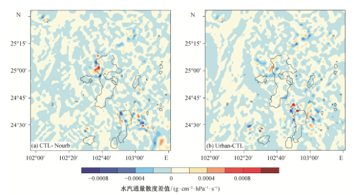
图 5给出降水时段内不同试验在 750 hPa 高度的水汽通量散度差值场。水汽通量散度为单位时间内单位体积中水汽的变化量, 可以用来表示某区域内水汽的辐合或辐散。通过对比图 4 和 5, 可以发现水汽通量散度的差值场与累积降水差值场之间存在很好的关联性。与 Nourb 试验相比, CTL试验水汽通量散度减小的区域正好对应累积降水增加的区域, 说明城市的存在使得该区域的水汽辐合加强(图 5(a))。当城市进一步扩大, 该区域的水汽通量散度进一步减小, 水汽辐合更为强烈(图 5(b))。城市的存在使得水汽向城市下风向聚集, 有利于降水在城市下风向区域发生。
图5 各组试验模拟得到的降水时段内750 hPa高度上的水汽通量散度差值场 Fig. 5 Difference distribution for CTL-Nourb and Urban-CTL of water vapor flux divergence at 750 hPa for the precipitation period
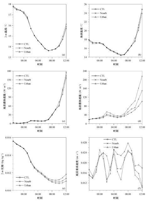
图6 2012年5月24日21:00至25日12:00各试验模拟得到的城区格点地表气象要素的时间序列 Fig. 6 Time series of different simulation for surface meteorological variables over the urban region from 21:00 May 24 to 12:00 May 25, 2012
为了进一步分析城市下垫面对降水的影响, 图6给出不同试验模拟得到的地表气象要素时间序列, 其中垂直速度值取自模式最底层(即距离地表约 45 m处)。气象要素值为城市格点(图 2 中的黑框所示)的平均值, 降水发生时段为5 月 24 日 21:00 至 25日 05:00。可以看出, 3 个试验模拟得到的地表温度之间的差别比 2 m 气温更明显; Urban 试验模拟得到的地表温度最高, Nourb 试验的地表温度最低; 与地表温度的模拟相比, 3 个试验模拟的 2 m 温度的差异性要小很多。
在降水时段内, 3 个试验模拟的感热通量之间的差异也较小, 这可能与降水发生在夜间有关(夜间地表的感热通量较小, 仅 10~20 W/m2)。但在04:00 前后仍可以观察到 Urban 试验得到的感热通量最大, Nourb 试验最小, 与地表温度的模拟结果一致。与感热通量不同, 各试验模拟得到的潜热通量在城区有明显的差别, 随着城市面积的扩大, 潜热通量会相应地减小。在 Nourb 试验中, 将城市下垫面替换为农田后, 潜热通量增加约 10 W/m2。2 m 比湿的变化与潜热一致, Nourb模拟的比湿最大, CTL试验次之, Urban试验的模拟值最小。
3个试验模拟得到的低层垂直速度有较大区别, 当城市存在时, 由于城市下垫面对低层大气的加热作用, 使得垂直运动加强, 这种现象在城市扩大后会更明显。从图 6 可以看出, 城市下垫面的变化对城区地面气象要素的影响主要体现在温度、潜热以及垂直速度 3 个方面。来自地面的水汽通过边界层进入大气, 成为降水重要的水汽源之一, 而地面的感热和潜热通量则是大气重要的热源和位势不稳定源[44,45]。当城区下垫面改变为农田后, 尽管更多的水汽被输送到大气中, 但地表温度和不稳定性的降低, 会抑制对流的发展[46,47]。
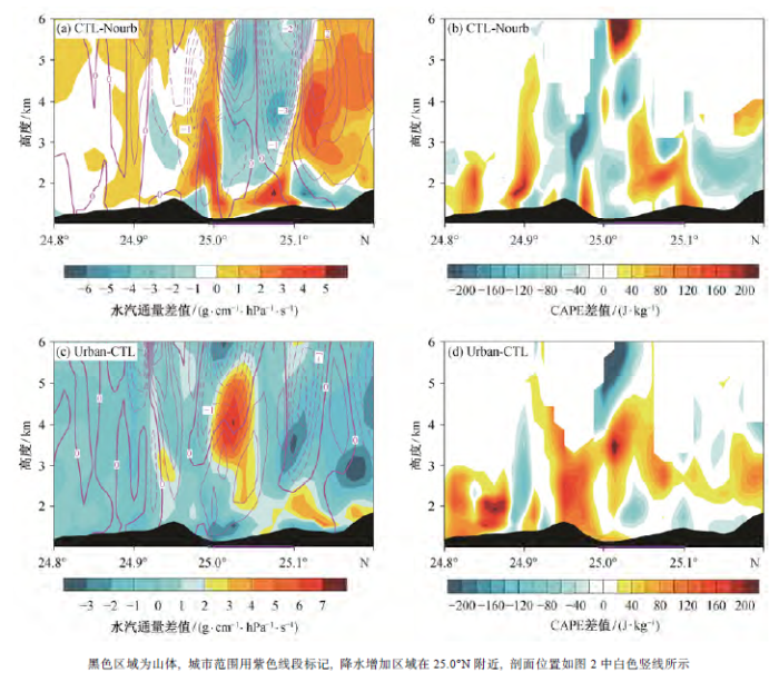
图7 和图8为 25 日 00:00 (即最大降水发生时)不同试验南北和东西走向剖面的水汽通量、垂直速度以及对流有效位能(convective available potential energy, CAPE)差值场, 两个剖面均经过城区下风向降水增加的区域(具体位置如图 4 所示), 降水增加区域在纬度 25.0°N 附近。从图 7(a)和(b)可以看出, 城市的存在使得城市的西南边界处(25.0°N 附近)的对流强度增强, 垂直速度增加约 1 m/s, 同时水汽在此处聚集, 并被输送到 3 km左右的高层大气中。通过 CAPE 的差值场可以发现, 城市的存在使得城市下风向区域的 CAPE 值增加60~200 J/kg, 有利于垂直对流运动的发展。在 CTL 试验中, 城区上空高层大气中水汽通量比 Nourb 试验略低一些, 使得 CTL 试验模拟得到的城区降水中心的降水量较小。当城市扩张后, 整个城区上空的垂直速度以及CAPE 都会有所增加, 更强的对流运动会将更多的近地面水汽输送到高层大气中。因此, 尽管在Urban试验中城区低层大气中的水汽通量减少了2~3 g/(cm·hPa·s), 但高层大气中的水汽通量比 CTL试验增加 4~6 g/(cm·hPa·s), CAPE在城区及其南面均有所增加, 为降水的发展提供了有利条件(图 7(c)和(d))。
图7 2012年5月25日00:00南北向剖面水汽通量、垂直速度((a)和(c))及对流有效位能((b)和(d))差值场 Fig. 7 Difference of water vapor flux superposed with vertical velocity ((a) and (c)) and CAPE ((b) and (d)) in height-latitude cross section at 00:00 LST on May 25, 2012
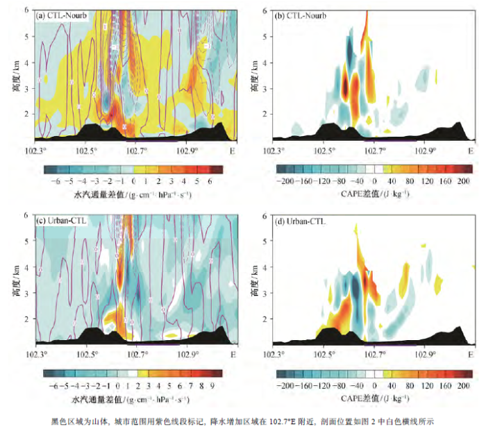
图8 2012年5月25日00:00东西向剖面水汽通量、垂直速度((a)和(c))及对流有效位能((b)和(d))差值场 Fig. 8 Difference of water vapor flux superposed with vertical velocity ((a) and (c)) and CAPE ((b) and (d)) in height-latitude cross section at 00:00 LST on May 25, 2012
通过东西向的剖面图也可以发现类似的物理过程。如图 8 所示, 降水增加的区域为 102.7°E, 即 城区的西侧。城市的存在使得水汽通量在此处(即城市下风向)聚集, 同时流经城市的东北风与流经湖区的东南风也在此处汇集, 产生较强的上升运动和较大的 CAPE, 利于降水的形成。当城市进一步扩大后, 低层水汽通量的改变不大, 差值在-2~4 g/(cm·hPa·s)范围内, 城市发展对降水的影响主要通过垂直对流运动的增强和CAPE的增大来实现。
为了探究昆明地区城市化对降水的影响, 本文利用中尺度气象模式WRF耦合单层城市冠层模块, 对2012年5月24日夜间发生在昆明城区西部的一次强降水过程进行了数值模拟研究, 结果如下。
1) 与卫星观测结果的对比表明, 尽管降水中心模拟的强度低于卫星观测的结果, 但 WRF 模式较好地模拟出昆明城区西部的降水过程。城市的存在使得位于昆明城区的降水中心累积降水减少 25~ 30 mm, 而城区西南面(城区下风向)的降水增加约30 mm。流经城市的东北风与流经湖区的东南风的交汇区域正是降水增加的区域, 同时也是 750 hPa 高度上水汽通量辐合加强的区域。通过敏感性试验发现, 当城市面积进一步扩大后, 城区下风向的降水会得到增强, 城区降水中心的降水量则略有减少。
2) 在此次降水过程中, 城市的存在明显地改变城区地表潜热通量、2 m 比湿和近地面垂直运动。当城市面积增加后, 城区的潜热通量减少 5~10 W/m2。不同数值试验模拟得到的低层垂直速度有较大差别, 差异在 0.002~0.008 m/s之间。在本文的个例研究中, 将城区下垫面替换为农田后, 城区的降水强度有所增强, 这可能与农田可为大气提供更为充足的水汽有关。
3) 城市的存在使城区下风向区域的垂直运动速度增大, CAPE增加。在城区下风向区域, 相对较强的垂直运动及不稳定性使得更多的水汽被输送到高层大气中, 有利于降水发生。当城市扩张后, 尽管城区低层的水汽通量减少 2~3 g/(cm·hPa·s), 但更强的垂直运动会使高层的大气水汽通量增加4~6 g/(cm·hPa·s), CAPE 在城区及其南面均有增加, 为降水的发展提供了有利条件。
需要指出的是, 本文仅对发生在昆明的一次强降水个例做了研究, 由于城市化主要通过改变地表性质影响局地大气动力和热力过程, 因此城市化在降水触发阶段和发展初期所起的作用可能较大, 本文的结论需要通过更多的观测资料和个例分析来验证。此外, 昆明及其周边的城市群在我国季风系统中所处的位置非常关键, 其城市化发展可能会对我国季风区的大气环流及季风降水产生影响, 这一点需要更进一步的深究。
The authors have declared that no competing interests exist.
城市及乡村大气边界层结构的数值模拟 An observational and modeling study of characteristics of urban heat island and boundary layer structures in Beijing MM5 和 WRF 对北京地区低层大气局地环流模拟能力的对比研究 Numerical study the effects of topography and urbanization on the local atmospheric circulations over the Beijing-Tianjin-Hebei,China 多尺度大气边界层与陆面物理过程模式的研究进展 Thunderstorm-breeding spots A preliminary examination of the possible effect of London’s urban area on the dis-tribution of thunder rainfall The La Porte weather anomaly — fact or fiction Man-made climatic changes man’s activities have altered the climate of urbanized areas and may affect global climate in the future Climatological assessment of urban effects on precipitation at St Urban heat islands and summertime convective thunderstorms in Atlanta: three case studies Radar sig-natures of the urban effect on precipitation distribu-tion: a case study for Atlanta,Georgia Impact of urbanization on recent temperature and precipitation trends in the Korean peninsula Urban impacts on precipitation Linearized calculations of urban heat island convection effects Numerical simulation of the effects of St A theoretical and numerical study of urban heat island-induced circulation and convec-tion Effects of boundary-layer stability on urban heat island-induced circulation Impact of the urban heat island effect on precipitation over a complex geographic environment in northern Taiwan Urban heat islands and summertime convective thunderstorms in Atlanta: three case studies Enhancement of afternoon thunderstorm activity by urbanization in a valley: Taipei Urban modification in a mesoscale model and the effects on the local circulation in the Pearl River Delta region Impacts of urban processes and urbanization on summer precipitation: a case study of heavy rainfall in Beijing on 1 August Suppression of rain and snow by urban and industrial air pollution Midweek increase in US summer rain and storm heights suggests air pollution invigorates rainstorms Aerosols and associated precipitation patterns in Atlanta Factors determining the impact of aerosols on surface precipitation from clouds: an attempt at classification Notes on state-of-the-art investigations of aerosol effects on precipitation: a critical review A global land cover climatology using MODIS data Explicit forecasts of winter precipitation using an improved bulk microphysics scheme Radiative forcing by long-lived greenhouse gases: calculations with the AER radiative transfer models Coupling an advanced land surface-hydrology model with the Penn State-NCAR MM5 modeling system. Part I: Model implementation and sensitivity A simple single-layer urban canopy model for atmospheric models: comparison with multi-layer and slab models Coupling a single-layer urban canopy model with a simple atmospheric model: impact on urban heat island simulation for an idealized case The Kain-Fritsch convective parameteri-zation: an update Nonlocal boundary layer vertical diffusion in a medium-range forecast model A revised approach to ice microphysical processes for the bulk paramete-rization of clouds and precipitation WRF model physics: problems, solutions and a new paradigm for progress. WRF Users’ Workshop, Boulder, CO, NCAR Fixing WRF’s high speed wind bias: a new subgrid scale drag parameterization and the role of detailed verification // 24th Conference on Weather and Forecasting/20th Conference on Nume-rical Weather Prediction The status of the tropical rainfall measuring mission (TRMM) after two years in orbit Impact of city belt in Yangtze River Delta in China on a precipitation process in summer: a case study 年 7 月 10 日北京局地暴雨数值模拟分析 陆气相互作用对中尺度对流系统影响的研究进展 Observed effects of landscape variability on convective clouds Transition of the rainfall characteristics related to the moistening of the land surface over the central Tibetan Plateau during the summer of
/
, Ping HE, Yucong MIAO
1 个例选取及试验方案设计
1.1 个例选取
1.2 WRF模式及试验方案设置
模式参数 WRF模式参数设置 模拟时间 2012‒05‒24 14:00至2012‒05‒25 20:00 水平分辨率 27, 4.5, 1.5 km 水平格点数 120×120, 131×131, 100×100 土地利用类型数据 MODIS 微物理参数化方案 Thompson graupel方案 辐射参数化方案 RRTMG方案 积云对流参数化方案 Kain-Fritsch方案 边界层参数化方案 YSU方案 陆面过程参数化方案 Noah陆面过程方案耦合UCM城市冠层方案
模拟试验 土地利用类型 CTL试验 使用MODIS地表利用类型数据 Nourb试验 将城市下垫面替换为农田 Urban试验 将城市周围的农田改为城市
2 模拟结果分析
2.1 模式验证
2.2 模拟结果分析
3 总结和讨论
参考文献
[1]
[2]
[3]
[4]
[5]
[6]
[7]
[8]
[9]
[10]
[11]
[12]
[13]
[14]
[15]
[16]
[17]
[18]
[19]
[20]
[21]
[22]
[23]
[24]
[25]
[26]
[27]
[28]
[29]
[30]
[31]
[32]
[33]
[34]
[35]
[36]
[37]
[38]
[39]
[40]
[41]
[42]
[43]
[44]
[45]
[46]
[47]

〈
〉