
Acta Scientiarum Naturalium Universitatis Pekinensis ›› 2017, Vol. 53 ›› Issue (5): 833-842.DOI: 10.13209/j.0479-8023.2017.041
• Orginal Article • Previous Articles Next Articles
Li XU1,2, Jianghai LI1,2( ), Chiheng LIU1,2, Xin CUI1,2
Received:2016-04-18
Revised:2016-05-16
Online:2017-09-20
Published:2017-09-20
许丽1,2, 李江海1,2(), 刘持恒1,2, 崔鑫1,2
基金资助:Li XU, Jianghai LI, Chiheng LIU, Xin CUI. Research on Geomorphological Morphology and Regionalization of Hoh Xil Based on Digital Elevation Model (DEM)[J]. Acta Scientiarum Naturalium Universitatis Pekinensis, 2017, 53(5): 833-842.
许丽, 李江海, 刘持恒, 崔鑫. 基于数字高程模型(DEM)的可可西里地貌及区划研究[J]. 北京大学学报自然科学版, 2017, 53(5): 833-842.
Add to citation manager EndNote|Ris|BibTeX
URL: https://xbna.pku.edu.cn/EN/10.13209/j.0479-8023.2017.041
| 海拔分级 | 面积/km2 | 比例/% |
|---|---|---|
| 中海拔(2749~3500 m) | 4904.32 | 1.99 |
| 高海拔(3500~5000 m) | 170747.70 | 69.38 |
| 极高海拔(5000~6642 m) | 70453.84 | 28.63 |
Table 1 Classification statistics according to altitude in Hoh Xil
| 海拔分级 | 面积/km2 | 比例/% |
|---|---|---|
| 中海拔(2749~3500 m) | 4904.32 | 1.99 |
| 高海拔(3500~5000 m) | 170747.70 | 69.38 |
| 极高海拔(5000~6642 m) | 70453.84 | 28.63 |
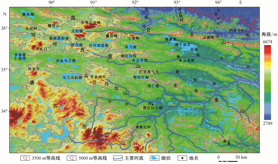
Fig. 1 Altitude classified map in Hoh Xil based on SRTM-DEM

Fig. 2 Relief amplitude classified map in Hoh Xil based on SRTM-DEM
| 起伏度分级 | 面积/km2 | 比例/% |
|---|---|---|
| 湖平面(0 m) | 4233.00 | 1.72 |
| 平原(0~30 m) | 65906.92 | 26.78 |
| 台地(30~70 m) | 56038.12 | 22.77 |
| 丘陵(70~200 m) | 83552.65 | 33.95 |
| 小起伏山地(200~500 m) | 34946.91 | 14.20 |
| 中起伏山地(500~1000 m) | 1427.41 | 0.58 |
Table 2 Classification statistics according to relief amplitude in Hoh Xil
| 起伏度分级 | 面积/km2 | 比例/% |
|---|---|---|
| 湖平面(0 m) | 4233.00 | 1.72 |
| 平原(0~30 m) | 65906.92 | 26.78 |
| 台地(30~70 m) | 56038.12 | 22.77 |
| 丘陵(70~200 m) | 83552.65 | 33.95 |
| 小起伏山地(200~500 m) | 34946.91 | 14.20 |
| 中起伏山地(500~1000 m) | 1427.41 | 0.58 |

Fig. 3 Slope degree classified map in Hoh Xil based on SRTM-DEM
| 坡度分级 | 面积/km2 | 比例/% |
|---|---|---|
| 平原(0°~0.5°) | 22207.69 | 9.02 |
| 微斜坡(0.5°~2°) | 67779.04 | 27.54 |
| 缓斜坡(2°~5°) | 58861.17 | 23.91 |
| 斜坡(5°~15°) | 70615.01 | 28.69 |
| 陡坡(15°~35°) | 26206.93 | 10.65 |
| 峭坡(35°~55°) | 434.58 | 0.18 |
| 垂直壁(55°~90°) | 1.40 | 0.01 |
Table 3 Classification statistics according to Slope degree in Hoh Xil
| 坡度分级 | 面积/km2 | 比例/% |
|---|---|---|
| 平原(0°~0.5°) | 22207.69 | 9.02 |
| 微斜坡(0.5°~2°) | 67779.04 | 27.54 |
| 缓斜坡(2°~5°) | 58861.17 | 23.91 |
| 斜坡(5°~15°) | 70615.01 | 28.69 |
| 陡坡(15°~35°) | 26206.93 | 10.65 |
| 峭坡(35°~55°) | 434.58 | 0.18 |
| 垂直壁(55°~90°) | 1.40 | 0.01 |
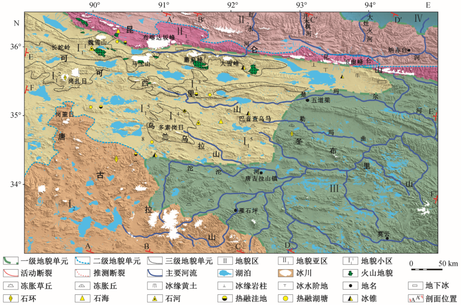
Fig. 4 Map of geomorphological regionalization and distribution of the special landforms in Hoh Xil

Fig. 5 Section map of geomorphological regionalization in Hoh Xil (section position as shown in Fig. 4)
| [1] | 李炳元, 潘保田, 程维明, 等 中国地貌区划新论.地理学报, 2013, 68(3):291-306 |
| [2] | 肖飞, 张百平, 凌峰, 等 基于DEM的地貌实体单元提取方法.地理研究, 2008, 27(2):459-466 |
| [3] | 沈玉昌, 苏时雨, 尹泽生 中国地貌分类、区划与制图研究工作的回顾与展望.地理科学, 1982, 2(2):97-105 |
| [4] | 郭子良, 崔国发 中国地貌区划系统: 以自然保护区体系建设为目标.生态学报, 2013, 33(19):6264-6276 |
| [5] | 闾国年, 钱亚东 基于栅格数字高程模型提取特征地貌技术研究.地理学报, 1998, 53(6):562-570 |
| [6] | 常直杨, 孙伟红, 王建, 等 数字高程模型在构造地貌形态分析中的应用现状及展望.南京师大学报: 自然科学版, 2015, 38(4):129-136 |
| [7] | Michael A.Geomorphology and global tectonics. London: John Wiley & Sons Press, 2000 |
| [8] | Balázs Székely.On the surface of the Eastern Alps — a DEM study. Tǜbingen: University Tǜbingen Press, 2001 |
| [9] | 程维明, 周成虎, 柴慧霞, 等 中国陆地地貌基本形态类型定量提取与分析.地球信息科学学报, 2009, 11(6):725-736 |
| [10] | 刘少峰, 王陶, 张会平, 等 数字高程模型在地表过程研究中的应用.地学前缘, 2005, 12(1):303- 309 |
| [11] | 葛肖虹, 刘俊来, 任收麦, 等 青藏高原隆升对中国构造‒地貌形成、气候环境变迁与古人类迁徙的影响.中国地质, 2014, 41(3):698-714 |
| [12] | 潘裕生 青藏高原的形成与隆升.地学前缘, 1999, 6(3):153-163 |
| [13] | 李炳元, 潘保田 可可西里东部地区的夷平面与火山年代.第四纪研究, 2002, 22(5):397-405 |
| [14] | 徐锡伟, 陈文彬, 于贵华, 等. 2001 年 11 月 14 日昆仑山库赛湖地震(MS 8.1)地表破裂带的基本特征.地震地质, 2002, 24(1): 1‒13 |
| [15] | 邓万明, 松本征夫 青海可可西里地区新生代火山岩的岩石特征与时代.岩石矿物学杂志, 1996, 15 (4):289-298 |
| [16] | 李树德, 李世杰 青海可可西里地区多年冻土与冰缘地貌.冰川冻土, 1993, 15(1):77-82 |
| [17] | 胡东生 可可西里地区湖泊概况.盐湖研究, 1994, 2(3):60-67 |
| [18] | 李炳元 青海可可西里地区综合科学考察初报.山地学报, 1990, 8(3):93-98 |
| [19] | 刘志飞, 王成善 可可西里盆地新生代沉积演化历史重建.地质学报, 2001, 75(2):250-258 |
| [20] | 徐贵忠, 常承法. 大陆岩石圈构造与资源.北京: 海洋出版社, 1992: 19‒32 |
| [21] | 陈守建, 李荣社, 计文化, 等 巴颜喀拉构造带二叠‒三叠纪岩相特征及构造演化.地球科学: 中国地质大学学报, 2011, 36(3):393-408 |
| [22] | 张以茀 青藏高原北部地质构造演化初论.青海地质, 1993, 2(2):1-7 |
| [23] | 叶建青 青海可可西里地区的活动构造与地震.高原地震, 1994, 6(2):11-23 |
| [24] | 邓起东, 程绍平, 马冀, 等.青藏高原地震活动特征及当前地震活动形势.地球物理学报, 2014, 57 (7): 2025‒2042 |
| [25] | 都昌庭 青海昆仑山口西 8.1 级地震前的尾波持续时间和地震频次.山西地震, 2003, 113(2):29-31 |
| [26] | Rabus B, Eineder M, Roth A, et al. The shuttle radar topography mission-a new class of digital elevation models acquired by spaceborne radar. ISPRS Journal of Photogrammetry & Remote Sensing, 2003, 57:241-262 |
| [27] | United States Geological Survey. Shuttle radar topo-graphy mission documentation: SRTM Topo [EB/OL]. (2015‒12‒08) [2016‒03‒18]. |
| [28] | 中国科学院地理研究所. 中国 1:100 万地貌制图规范(征求意见稿). 北京: 科学出版社, 1987 |
| [29] | 朱红春, 陈楠, 刘海英, 等 自 1:10000 比例尺DEM 提取地形起伏度: 以陕北黄土高原的实验为例.测绘科学, 2005, 30(4):86-88 |
| [30] | 刘静, 丁林, 曾令森, 等 青藏高原典型地区的地貌量化分析: 兼对高原“夷平面”的讨论.地学前缘, 2006, 13(5):285-299 |
| [31] | 潘保田, 高红山, 李炳元, 等 青藏高原层状地貌与高原隆升.第四纪研究, 2004, 24(1):50-57 |
| [32] | 曹伟超, 陶和平, 孔博, 等 青藏高原地貌形态总体特征的 GIS 识别分析.水土保持通报, 2011, 31 (4):163-167 |
| [33] | 边千韬, 常承法 青海可可西里大地构造基本特征.地质科学, 1997, 32(1):37-46 |
| [34] | 龙恩, 程维明, 周成虎, 等 基于 Srtm-DEM 与遥感的长白山基本地貌类型提取方法.山地学报, 2007, 25(5):557-565 |
| [35] | 邵兆刚, 孟宪刚, 朱大岗, 等 青藏高原层状地貌特征及其成因初探.地学前缘, 2009, 16(6):186- 194 |
| [36] | 潘保田, 高红山, 李吉均 关于夷平面的科学问题: 兼论青藏高原夷平面.地理科学, 2002, 22(5):520-526 |
| [37] | 李亚林, 王成善, 伊海生, 等 西藏北部新生代大型逆冲推覆构造与唐古拉山的隆起.地质学报, 2006, 80(8):1118-1130 |
| [38] | 莫宣学, 罗照华, 邓晋福, 等 东昆仑造山带花岗岩及地壳生长.高校地质学报, 2007, 13(3):403- 414 |
| [39] | 李永春, 陈大涌 高海拔地形区冰缘环境土壤特征的研究: 以青藏高原可可西里自然保护区为例.泉州师范学院学报, 2006, 23(2):47-50 |
| [40] | 江东辉, 刘嘉麒, 丁林 青藏高原北部可可西里地区新生代钾质火山岩地球化学特征及成因.岩石学报, 2008, 24(2):279-290 |
| [41] | 李世杰, 李树德 青海可可西里地区第四纪冰川与环境演化.冰川冻土, 1992, 14(4):316-324 |
| [1] |
YANG Liwen, ZHANG Yalin, MA Yali, LUAN Qing, HONG Dandan, WANG Dayong, XU Shuyuan.
Supply-Demand Balance of Ecosystem Flood Regulation Service and Flood Risk Management Zoning: A Case Study in Lan County, Shanxi Province
[J]. Acta Scientiarum Naturalium Universitatis Pekinensis, 2025, 61(3): 545-556.
|
| [2] | ZHAO Pengjun, YIN Zhaoyou, ZHANG Mengzhu, NIU Yingnan, HE Zhangyuan. Changes in World Corn Shipping Pattern under the Background of COVID-19 Pandemic and Russia-Ukraine Conflict [J]. Acta Scientiarum Naturalium Universitatis Pekinensis, 2024, 60(6): 1094-1106. |
| [3] | JIAN Yuqing, XU Kunjing, WANG Zhifang, HUANG Zhibin, YE Tao, JIANG Tianzi, CHENG Kexin. Recreational Ecosystem Services: Progress and Prospect [J]. Acta Scientiarum Naturalium Universitatis Pekinensis, 2023, 59(5): 884-896. |
| [4] | LIU Debin, JIN Zeyu, KE Zhifa, XU Fangfang. Regression Analysis of Building Scale Data and Estimation of Demolition Rate [J]. Acta Scientiarum Naturalium Universitatis Pekinensis, 2023, 59(4): 547-554. |
| [5] | WU Jiansheng, QIAN Yun, WANG Hongliang, ZHU Huizhen, WANG Han. Evaluation and Impact Factors of Spatial Supply and Demand of Public Sports Facilities in Shenzhen [J]. Acta Scientiarum Naturalium Universitatis Pekinensis, 2022, 58(6): 1101-1110. |
| [6] | DAI Yuwan, HOU Yubo. Impact of Socioeconomic Status Expectation on the Academic Achievement among Rural Students [J]. Acta Scientiarum Naturalium Universitatis Pekinensis, 2021, 57(5): 983-990. |
| [7] | YANG Liwen, WANG Dayong, LI Shuangcheng. Quantitative Assessment on Supply-Demand Budget of Culture Ecosystem Service: A Case Study in Pinglu Swan Scenic Spot [J]. Acta Scientiarum Naturalium Universitatis Pekinensis, 2021, 57(4): 691-698. |
| [8] | WANG Yalin, NIU Mingshuang, SONG Bo. Research on Supply and Demand of Habitat Maintenance Services: A Case Study of Beijing-Tianjin-Hebei Region [J]. Acta Scientiarum Naturalium Universitatis Pekinensis, 2021, 57(2): 381-389. |
| [9] | TANG Xiumei, LIU Yu, REN Yanmin, ZHOU Yanbing. Evaluation and Analysis of Ecosystem Services Value in Beijing-Tianjin-Hebei Region Based on Demand Zoning [J]. Acta Scientiarum Naturalium Universitatis Pekinensis, 2021, 57(1): 173-180. |
| [10] | WANG Chunhua, WANG Lei. Identity-Based Motivation Theory and Its Implication to Academic Outcome of College Students [J]. Acta Scientiarum Naturalium Universitatis Pekinensis, 2019, 55(6): 1170-1178. |
| [11] | PANG Yong, FENG Yajie, SUN Qichen, LAI Xiaomin, WANG Haiyuan, CHEN Xibao, LIANG Jieneng, LIU Tianxi. Simulation and Experimental Study on the Effect of Large Granular Rocks in Lunar Soil on Drilling Load [J]. Acta Scientiarum Naturalium Universitatis Pekinensis, 2019, 55(3): 397-404. |
| [12] | MA Yuxuan, LI Jianghai, CHEN Yaohua. Geomorphological Characteristics of the Quaternary Volcanoes and Their Tectonic Implications in Aershan Region, Central Greater Khingan Range [J]. Acta Scientiarum Naturalium Universitatis Pekinensis, 2019, 55(2): 289-298. |
| [13] | Xingguang WANG, Ruijie ZHANG, Yi ZHANG. Toponym Resolution Based on Geo-relevance and D-S Theory [J]. Acta Scientiarum Naturalium Universitatis Pekinensis, 2017, 53(2): 344-352. |
| [14] | XIAO Wei, YAO Xiang, QIU Yongtao. Constructing Chinese Remote Associates Test (RAT) with Application of Item Response Theory [J]. Acta Scientiarum Naturalium Universitatis Pekinensis, 2016, 52(2): 354-362. |
| [15] | LIU Xiaopeng;WEI Peng. Effect of Interdisciplinary Academic Exchange on Research Collaboration and Graduate Cultivation: A Case Study on Biomedical Interdisciplinary Lecture of Peking University [J]. Acta Scientiarum Naturalium Universitatis Pekinensis, 2015, 51(3): 571-576. |
| Viewed | ||||||
|
Full text |
|
|||||
|
Abstract |
|
|||||