据文献[1–2]修改; (a)中红框为(b)的范围; (b)中震源机制解引自文献[3]。EAFZ: 东安纳托利亚断裂带; NAFZ: 北安纳托利亚断裂带; DSFZ: 死海断裂带; EF: Ecemis断裂; SF: Sarız断裂; MF: Malatya断裂
图1 研究区所处大地构造位置(a)和区域构造简图(b)
Fig. 1 Geotectonic location (a) and regional tectonic map (b) of the study area
北京大学学报(自然科学版) 第59卷 第6期 2023年11月
Acta Scientiarum Naturalium Universitatis Pekinensis, Vol. 59, No. 6 (Nov. 2023)
doi: 10.13209/j.0479-8023.2023.081
收稿日期: 2023‒05‒11;
修回日期: 2023‒08‒11
摘要 2023年2月6日, 土耳其发生两次 M7.8 级地震, 在 Hatay 省形成地表破裂带。通过对 Hatay 省 Karatas和 Hassa 地区地表破裂带的初步野外调查, 发现断破裂带走向为 N5°E 至 N20°E, 延伸长度大于 40km, 性质为左旋逆冲, 最大同震位错的逆冲量为 50~60 cm, 走滑量为 2m 左右。此次地震始于 Narlı 断裂, 并向东安纳托利亚断裂带南北双向传播, 从而使得研究区断裂走滑位错自北向南有减小的趋势, 并逐渐尖灭消失。
关键词 土耳其7.8级地震; 东安纳托利亚断裂带; 地表破裂带; 同震位错
北京时间 2023年2月6日, 土耳其接连发生两次 7.8 级地震, 震源深度为 20km。两次地震均发生于东安纳托利亚断裂带(East Anatolian Fault Zone, EAFZ), 第一次位于南侧分支, 第二次位于北侧分支。这两个地震事件相对独立, 又相互触发, 给当地造成严重的生命财产损失。应土耳其政府请求, 中国政府于 2023年2月7日派遣中国救援队赴土耳其实施国际人道主义救援。根据中国救援队的部署, 本文第一作者对 Hatay 省的生命供给线、工业和建筑等进行地质灾害考察和评估, 其间发现地震造成的地表破裂带。本文简要介绍这条地表破裂带的基本特征, 初步分析其发震构造。
研究区位于土耳其东部, 地中海东岸, 东与叙利亚相邻, 地貌上属于安纳托利亚高原和伊朗高原的过渡地带。该区域受欧亚板块、阿拉伯板块和安纳托利亚板块的共同作用(图 1(a)), 形成北安纳托利亚断裂带(North Anatolian Fault Zone, NAFZ)和东安纳托利亚断裂带(East Anatolian Fault Zone, EAFZ)等多条大型走滑断裂带[1–2], 构造运动极为活跃, 形成以北安纳托利亚地震带、东安纳托利亚地震带以及西部地震区为主的“两带一区”的区域地震构造格 局[1]。该区域历史上地震活动频繁, 20 世纪以来多次发生 6 级以上的强震(图 1(b)), 造成大量建筑毁坏和人员伤亡。
东安纳托利亚断裂带是土耳其第二大断裂带, 走向为 NNE-NE, 从东安纳托利亚延伸至伊斯肯德伦湾的地中海, 全长 580km (图 1)。作为阿拉伯板块与安纳托利亚板块之间的活动板块边界, 东安纳托利亚左旋走滑断裂带和北安纳托利亚右旋断裂带的运动受阿拉伯板块北向碰撞作用的控制, 围限了安纳托利亚板块的运动(图 1(a))。东安纳托利亚断裂带左旋走滑断层的滑移率为 8~10mm/a[4], 但自东向西逐步降低, 从东部 Karlıova 附近的 10mm/a降至 Tüurkoglu 附近的 4mm/a, 并且向西进一步降至2.5mm/a[2]。
东安纳托利亚断带的主断裂自东向西可分为Karlıova段、Ilıca段、Palu段、Pütürge段、Erkenek段、Pazarcık 段和 Amanos 段, 此外还有自 Celikhan向西展布的 Cardak 段[5]。此次地震先后造成东安纳托利亚断裂带 NE-NNE 走向的 Erkenek 段、Pazarcık 段和 Amanos 段和 EW 走向的 Cardak 段的破裂变形。在过去 100 多年的历史上, 土耳其的主要地震发生在北安纳托利亚断裂带, 虽然东安纳托利亚断裂带也有地震, 但不如北安纳托利亚断裂带频繁。但是, 从历史地震来看, EAFZ 各段均发生过破裂。1789年的 M7.2 级地震、1874年的 M7.1 级地震和1875年的 M6.7 级地震使得 Palu 段发生破裂, 1795年的 M7.0 级地震使得 Pazarcık 段发生破裂, 1893年的 M7.1 级地震使得Erkenek段发生破裂, 1872年的M7.2 级地震在 Amanos 段造成显著的地表破裂。2020年Sivrice 的 6.8 级地震使得 Pütürge 段发生长达45km 的破裂[5–9]。

据文献[1–2]修改; (a)中红框为(b)的范围; (b)中震源机制解引自文献[3]。EAFZ: 东安纳托利亚断裂带; NAFZ: 北安纳托利亚断裂带; DSFZ: 死海断裂带; EF: Ecemis断裂; SF: Sarız断裂; MF: Malatya断裂
图1 研究区所处大地构造位置(a)和区域构造简图(b)
Fig. 1 Geotectonic location (a) and regional tectonic map (b) of the study area
由于断裂的几何复杂性, 断裂的传播往往受到走滑断裂弯曲的限制, 从而使得地表破裂带不连续出现[5,10]。对于这些地表破裂带的位置和形态, 目前尚缺少详细的研究。
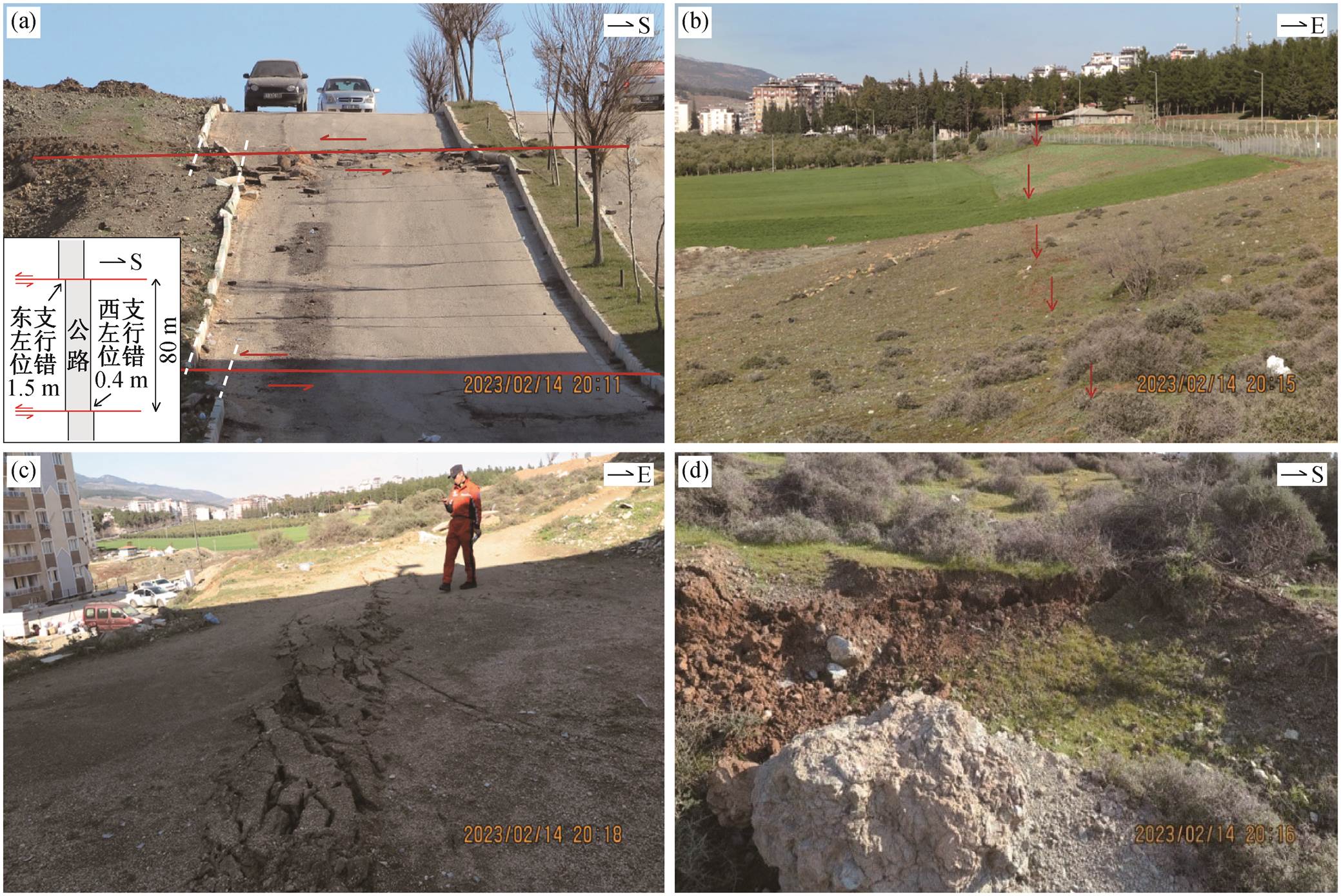
Karatas 地区(N36.4834°, E36.3334°)地表破裂带整体呈 N20°E走向, 连续性较好。断裂带由平行的东西两支组成(图 2(a)), 相距约 80m, 使得公路被左行错断。西支破裂规模较小, 测得左行位错量约为0.4m; 东支破裂带由雁行状张剪破裂排列组成(图2(b)和(c)), 测得左行位错量约为 1.5m, 垂直位错不明显, 表现为断层坎(d))。破裂带向南规模逐渐变小, 并逐渐尖灭消失。
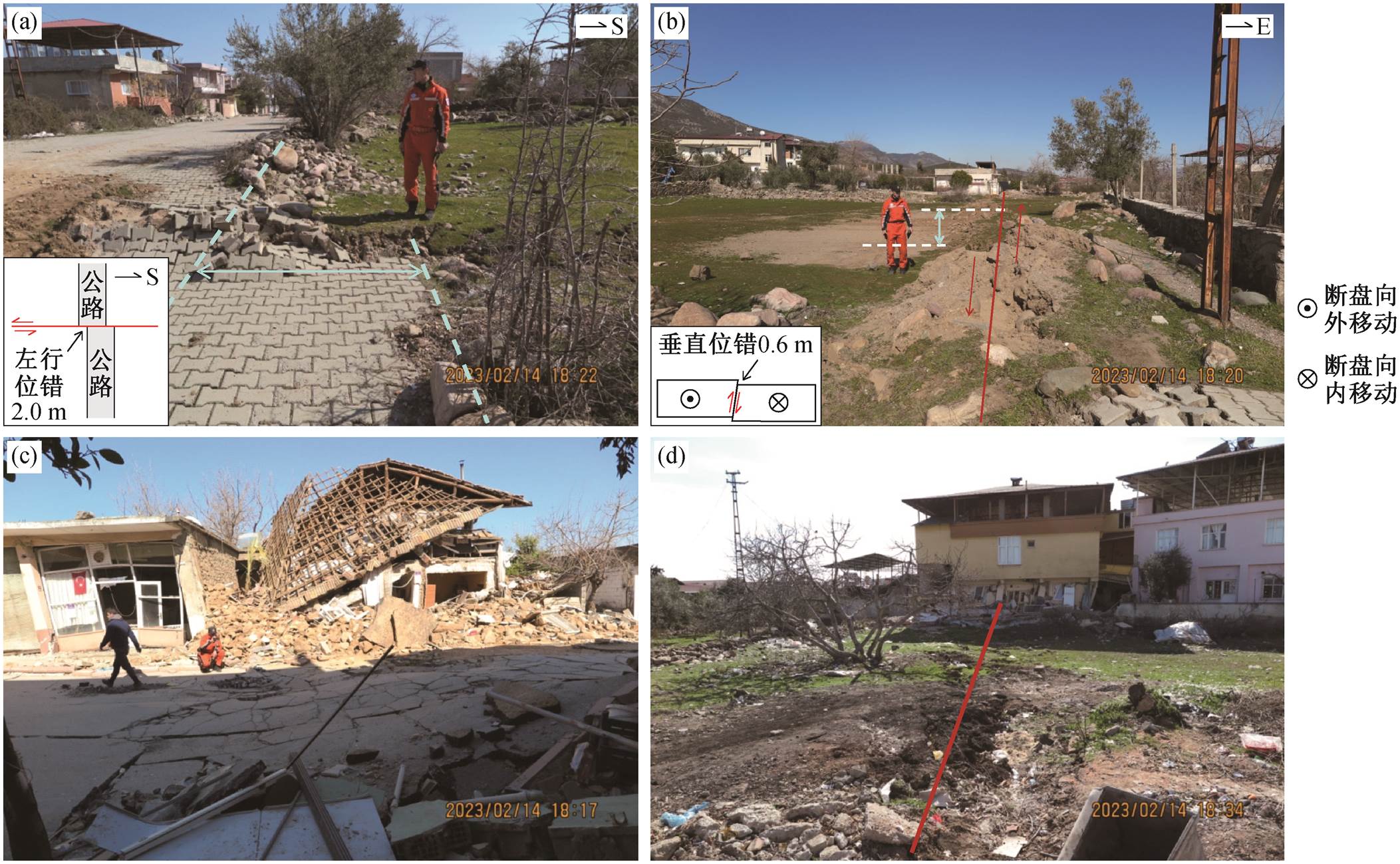
Hassa 地区地表破裂带位于 Karatas 地区以北约40km。该处破裂带(N36.8000°, E36.5167°)的走向为 N4°E, 宽度约为 10m。破裂带横穿 Hassa 镇, 使得道路被左行错断, 测得最大左行位错量约为 2.0m (图 3(a)), 并形成挤压逆冲断层陡坎, 破裂面倾向SE, 倾角为 80°, 最大逆冲垂直位错为 0.6m(图 3 (b))。NW 向地表裂隙与破裂带相交, 与主破裂形成30°~40°的夹角。NW 向地表裂隙长度最长可达十余米, 宽 1~3cm。沿破裂带, 建筑物和道路损毁严重(图 3(c)和(d)), 但影响范围不大, 距离破裂带约10m 的建筑物基本上完好。如图 3(d)所示, 破裂带穿过的黄色建筑损坏, 而相邻的结构相同的白色建筑基本上完好。
受限于救援时间和区域, 本次工作仅对 Karatas和 Hassa 地区的地表破裂带进行了野外考察, 未能对地表破裂带的整体分布情况进行详细的调查。事实上, 在断裂沿线广泛发育典型的的地表破裂带。本文对震区的高空间分辨率光学遥感影像(来源于Maxar 公司针对灾害的开放数据计划: https://www. maxar.com/open-data/turkey-earthquake-2023)进行解译。这些影像的成像时间为地震发生后, 空间分辨率可达米级。我们发现在 Hassa 以北的地区, 断裂的地表行迹非常明显, 引发本次地震的断裂已破裂至地表, 并错断公路、农田和水渠等(图 4), 错断距离在 1.8m 左右。
此次地震造成东安纳托利亚断裂带 NE 走向的Amanos 断裂和 EW 走向的 Cardak 断裂的先后破裂变形。本文报道的地表破裂带位于东安纳托利亚断裂带西南部的 Amanos 段, 该段地震活跃度相对较低, 复发时间较长, 是一个显著的地震空区, 历史上最近发生的地震是公元 601年的 M7 级地震、1822年的 M7.5 地震和 1872年的 M7.2 级地震。事实上, 就东安纳托利亚断裂带来说, 自 1114年大地震(≥ M7.8)以来, 从未有过与本次地震类似的大规模地表破裂[6,10−12]。本文报道的地表破裂最大同震位错约为 2.0m, 显著低于此次地震造成的位错的平均水平(最大 7.30m, 平均 3.0m)。这一现象可能是由Amanos 段的性质决定的。该段为东安纳托利亚断裂带最南段, 位于死海断层(DSF)与塞浦路斯岛弧(Cyprus Arc)之间[5], 东安纳托利亚断裂带至此分叉为 Antakya 断裂和 DSF 断裂, Amanos 断裂表现为东安纳托利亚断裂带向死海断裂和塞浦路斯岛弧的过渡, 地表破裂带以雁行张裂为主, 走滑位错自北向南逐渐减少。
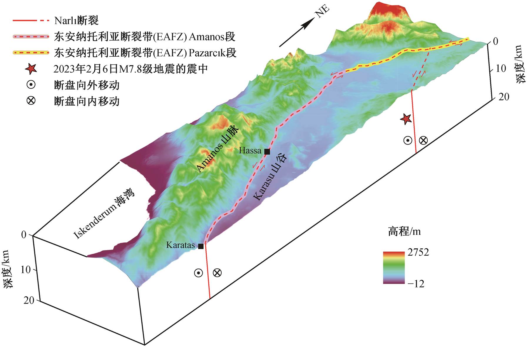
此外, 本文报道的逆冲分量可能只是局部的特点, 从深部地球物理特征来看, 作为阿拉伯地块与安纳托利亚地块之间的边界, Hatay 地区的 Ama-mos 断裂段表现为纯粹的走滑机制[13], 对震源机制解和断层面解的研究[14]也证实了这一点。综合近期对此次地震滑动位错分布[15]、同震地表形变[16]以及破裂过程[11–12,17]的研究结果, 本文认为此次地震始于 Narlı 断裂, 到达与 Pazarcık 段的交界处后, 在东安纳托利亚断裂带向南北双向传播, 并跳跃释放, 向南终止于 Amanos 段, 其余震沿 Antakya 断裂向地中海盆地延伸, 形成 Mw6.4 级的余震, 向北到达 Pütürge 段南缘, 至 Yarpuzlu 附近的走滑弯曲处终止(图 5)。

图2 Karatas地区地表破裂带
Fig. 2 Surface ruptures in Karatas

图3 Hassa地区地表破裂带
Fig. 3 Surface ruptures in Hassa

(a)和(b)错断的道路; (c)和(d)错断的农田及道路。(a) N36.6162°, E37.0159°; (b) N36.7317°, E37.2008°; (c) N36.8718°, E37.3762°; (d) N36.9019°, E37.4013°
图4 Hassa以北地区地表破裂带卫星影像
Fig. 4 Characteristics of the surface ruptures in the North of Hassa revealed by satellite images

图5 土耳其M7.8级地震的发震构造
Fig. 5 Seismogenic structure map of Turkey M7.8 earthquake
致谢 中国地震局工程力学研究所王涛博士参加野外考察, 并协助完成本文地表破裂带特征分析工作, 谨致谢忱。
参考文献
[1] 韩竹军, 张国民. 伊兹米特地震发生的构造环境分析. 国际地震动态, 2000(1): 1–7
[2] Güvercin S, Karabulut H, Konca A, et al. Active seis-motectonics of the East Anatolian Fault. Geophysical Journal International, 2022, 230(1): 50–69
[3] USGS. M 7.8-Pazarcik earthquake, Kahramanmaras earthquake sequence [EB/OL]. (2023–02–06) [2023–08–14]. https://earthquake.usgs.gov/earthquakes/event page/us6000jllz/moment-tensor.2023
[4] Reilinger R, McClusky S, Vernant P, et al. GPS constraints on continental deformation in the Africa-Arabia-Eurasia continental collision zone and implica-tions for the dynamics of plate interactions. Journal of Geophysical Research: Solid Earth, 2006, 111: B05411
[5] Duman T, Emre Ö. The East Anatolian Fault: geometry, segmentation and jog characteristics // Robertson A H F, Parlak O, Ünlügenç U C. Geological development of anatolia and the easternmost mediterranean region. Geological Society, London, Special Publications, 2013, 372: 495–529
[6] Ambraseys N, Finkel C. The seismicity of Turkey and adjacent areas 1500–1800. Istambul: Eren Yayincilik, 1995
[7] Irmak T, Toker M, Yavuz E, et al. New insight into the 24 January 2020, Mw 6.8 Elazığ earthquake (Turkey): an evidence for rupture-parallel pull-apart basin acti-vation along the East Anatolian Fault Zone constrained by Geodetic and Seismological data. Annals of geo-physics, 2021, 64: 1–13
[8] Konca A, Karabulut H, Güvercin S, et al. From inter-seismic deformation with near-repeating earthquakes to co-seismic rupture: a unified view of the 2020 Mw 6.8 Sivrice (Elazığ) eastern Turkey earthquake. Jour-nal of Geophysical Research: Solid Earth, 2021, 126: e2021JB021830
[9] Tan O, Tapırdamaz M, Yoruk A. The earthquake cata-logues for Turkey. Turkish Journal of Earth Science, 2008, 17: 405–418
[10] Ambraseys N. Temporary seismic quiescence: SE Tur-key. Geophysical Journal International, 1989, 96: 311–331
[11] Karabulut H, Güvercin S, Hollingsworth J, et al. Long silence on the East Anatolian Fault Zone (Southern Turkey) ends with devastating double earthquakes (6 February, 2023) over a seismic gap: implications for the seismic potential in the Eastern Mediterranean re-gion. Journal of the Geological Society, 2023, 180(3): 1–10
[12] Xu L, Mohanna S, Meng L, et al. The 2023 Mw7.8 Kahramanmaraş, Turkey earthquake: a multi-segment rupture in a millennium supercycle [EB/OL]. (2023–02–23)[2023–08–14]. https://www.researchsquare.com/ article/rs-2747911/v1
[13] Over S, Akin U, Sen R. Geophysical data (gravity and magnetic) from the area between Adana, Kahraman-maras and Hatay in the Eastern Mediterranean region: tectonic implications. Pure and Applied Geophysics, 2018, 175: 2205–2219
[14] Örgülü G, Aktar M, Türkelli N, et al. Contribution to the seismotectonics of Eastern Turkey from moderate and small size events. Geophysical Research Letters, 2003, 30: 8040
[15] Barbot S, Luo H, Wang T, et al. Slip distribution of the February 6, 2023 Mw 7.8 and Mw 7.6, Kahramanmar-aş, Turkey earthquake sequence in the East Anatolian Fault Zone. Seismica, 2023, 2(3): 1–17
[16] Li S, Wang X, Tao T, et al. Source model of the 2023 Turkey earthquake sequence imaged by sentinel-1 and GPS measurements: implications for heterogeneous fault behavior along the East Anatolian Fault Zone. Remote Sensing, 2023, 15(10): 2618
[17] Melgar D, Taymaz T, Ganas A, et al. Sub- and super-shear ruptures during the 2023 Mw 7.8 and Mw 7.6 earthquake doublet in SE Türkiye. Seismica, 2023, 2 (3): 1–10
Preliminary Investigation on the Surface Ruptures of the Turkey M7.8 Earthquake on February 6, 2023
Abstract Two M7.8 earthquakes struck southern and central Turkey on February 6, 2023, forming typical surface ruptures in Hatay Province. Earthquake surface raptures geometry and displacement characteristics were investigated in Karatas and Hassa regions. Preliminary results show that the rupture with strike of N5°E–N20°E extends over 40 km. Left-lateral strike-slip faulting developed with an average horizontal displacement of 50–60 cm and maximum horizontal displacement of 2 m. The earthquake development started on Narlı Fault, transferred to the main fault and propagated to south and north across the main fault of East Anatolian Fault Zone, which lead to the decreasing of the horizontal coseismic displacement in research area.
Key words M7.8 earthquake in Turkey; East Anatolia Fault Zone; surface rupture; coseismic displacement